Muhoroni geodata
Muhoroni (Kisumu) is a populated place; located in Kenya in Africa/Nairobi (GMT+3) time zone. With population of 15,217 people, there are 51 cities with bigger population in this country. Compared to other cities in Kenya, 63.2% of cities are located further ↓South; 70.2% of cities are located further →East and 50.9% of cities have lower elevation than Muhoroni. Note1


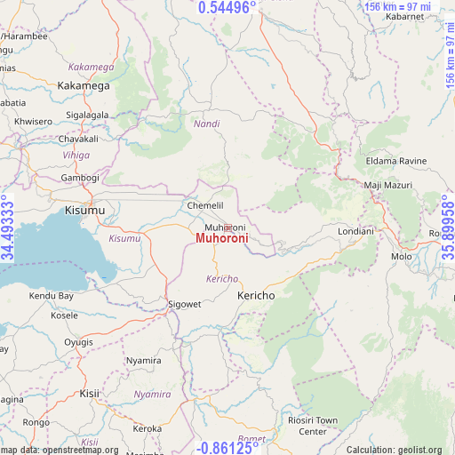
Muhoroni GPS coordinates[2]
0° 9' 29.376" South, 35° 11' 47.22" East
| Map corner | latitude | longitude |
|---|---|---|
| Upper-left | 0.54496°, | 34.49333° |
| Center: | -0.15816°, | 35.19645° |
| Lower-right: | -0.86125°, | 35.89958° |
| Map W x H: | 156.4×156.4 km | = 97.2×97.2mi |
| max Lat: | 3.93726° ⇑36.8% North |
| Muhoroni: | -0.15816° |
| min Lat: | ⇓63.2% South -4.64756° |
| min Long | Muhoroni | max Long |
| 33.97248° | 35.19645° | 41.85688° |
| W 29.8%⇐ | ⇒70.2% E |
Elevation
Elevation of Muhoroni is 1462 m = 4797 ft, and this is 115.3 m = 378 ft above average elevation for this country.
| Max E: |
2514 m = 8248 ft | 49.1% |
| Muhoroni | 1462 m 4797 ft | |
| Avg. | 1346.7 m = 4418 ft | |
Min E: |
7 m = 23 ft | 50.9% |
See also: Kenya elevation on elevation.city.
Geographical zone
Muhoroni is located in South Torrid zone (between Equator and Tropic of Capricorn). Distance of Equator is 17.6 km =10.9 mi to North.| Distance of | km | miles | from Muhoroni |
|---|---|---|---|
| Equator | 17.6 | 10.9 | to North |
| Tropic Capricorn | 2588.3 | 1608.3 | to South |
| Antarctic Circle | 7383.6 | 4588 | to South |
| South Pole | 9989.5 | 6207.2 | to South |


Nearby cities:
15 places around Muhoroni: (largest is in red/bold)
• Ahero
30.9 km =19.2 mi,  266°
266°
• Eldama Ravine
63.5 km =39.5 mi,  68°
68°
• Kakamega
69.7 km =43.3 mi,  314°
314°
• Kapsabet
41.5 km =25.8 mi,  345°
345°
• Kericho
25.2 km =15.7 mi,  157°
157°
• Kipkelion
30.5 km =19 mi,  98°
98°
• Kisumu
48.7 km =30.3 mi,  277°
277°
• Litein
47.2 km =29.3 mi,  180°
180°
• Londiani
44.2 km =27.5 mi,  91°
91°
• Mbale
59.2 km =36.8 mi,  296°
296°
• Molo
60.4 km =37.5 mi, 99°
• Nandi Hills
29.1 km =18.1 mi,  357°
357°
• Nyamira
53.6 km =33.3 mi,  212°
212°
• Oyugis
64.9 km =40.3 mi,  232°
232°
• Sotik
60 km =37.3 mi,  189°
189°
Sources, notices
• [Note1] Compared only with cities in Kenya existing in our database
• [Src1] Map data: © OpenStreetMap contributors (CC-BY-SA)
• [Src2] Other city data from geonames.org with taken over terms of usage.
• [Src3] Geographical zone / Annual Mean Temperature by Robert A. Rohde @ Wikipedia
