Litein geodata
Litein (Kericho) is a populated place; located in Kenya in Africa/Nairobi (GMT+3) time zone. With population of 3,129 people, there are 100 cities with bigger population in this country. Compared to other cities in Kenya, 54.4% of cities are located further ↑North; 71.1% of cities are located further →East and 78.9% of cities have lower elevation than Litein. Note1


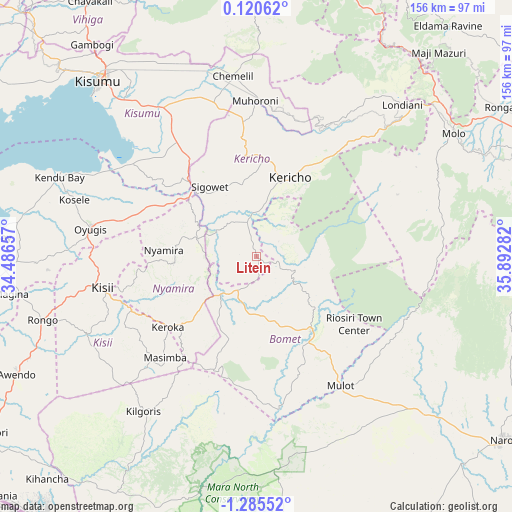
Litein GPS coordinates[2]
0° 34' 56.964" South, 35° 11' 22.884" East
| Map corner | latitude | longitude |
|---|---|---|
| Upper-left | 0.12062°, | 34.48657° |
| Center: | -0.58249°, | 35.18969° |
| Lower-right: | -1.28552°, | 35.89282° |
| Map W x H: | 156.3×156.4 km | = 97.1×97.2mi |
| max Lat: | 3.93726° ⇑54.4% North |
| Litein: | -0.58249° |
| min Lat: | ⇓45.6% South -4.64756° |
| min Long | Litein | max Long |
| 33.97248° | 35.18969° | 41.85688° |
| W 28.9%⇐ | ⇒71.1% E |
Elevation
Elevation of Litein is 1940 m = 6365 ft, and this is 593.3 m = 1947 ft above average elevation for this country.
| Max E: |
2514 m = 8248 ft | 21.1% |
| Litein | 1940 m 6365 ft | |
| Avg. | 1346.7 m = 4418 ft | |
Min E: |
7 m = 23 ft | 78.9% |
See also: Kenya elevation on elevation.city.
Geographical zone
Litein is located in South Torrid zone (between Equator and Tropic of Capricorn). Distance of Equator is 64.8 km =40.3 mi to North.| Distance of | km | miles | from Litein |
|---|---|---|---|
| Equator | 64.8 | 40.3 | to North |
| Tropic Capricorn | 2541.2 | 1579 | to South |
| Antarctic Circle | 7336.4 | 4558.6 | to South |
| South Pole | 9942.3 | 6177.9 | to South |


Nearby cities:
15 places around Litein: (largest is in red/bold)
• Ahero
54.5 km =33.9 mi,  326°
326°
• Kericho
26 km =16.2 mi,  23°
23°
• Keroka
34.5 km =21.4 mi,  231°
231°
• Kipkelion
52.6 km =32.7 mi,  35°
35°
• Kisii
48.3 km =30 mi,  256°
256°
• Kisumu
71.5 km =44.4 mi,  318°
318°
• Londiani
64.5 km =40.1 mi, 44°
• Molo
70.8 km =44 mi,  58°
58°
• Muhoroni
47.2 km =29.3 mi,  0°
0°
• Nandi Hills
76.3 km =47.4 mi,  359°
359°
• Nyamira
28.3 km =17.6 mi,  274°
274°
• Ogembo
57 km =35.4 mi,  244°
244°
• Oyugis
51.7 km =32.1 mi,  279°
279°
• Sotik
14.9 km =9.3 mi,  216°
216°
• Sotik Post
27.8 km =17.3 mi,  142°
142°
Sources, notices
• [Note1] Compared only with cities in Kenya existing in our database
• [Src1] Map data: © OpenStreetMap contributors (CC-BY-SA)
• [Src2] Other city data from geonames.org with taken over terms of usage.
• [Src3] Geographical zone / Annual Mean Temperature by Robert A. Rohde @ Wikipedia
