Mbale geodata
Mbale (Vihiga) is a seat of a first-order administrative division; located in Kenya in Africa/Nairobi (GMT+3) time zone. In our database, there are 111 cities with bigger population. Compared to other cities in Kenya, 69.3% of cities are located further ↓South; 84.2% of cities are located further →East and 61.4% of cities have lower elevation than Mbale. Note1


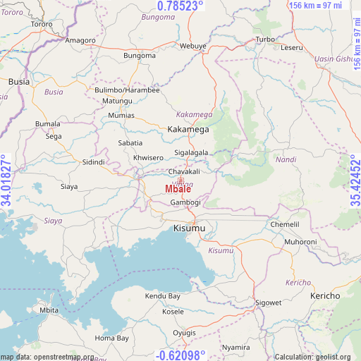
Mbale GPS coordinates[2]
0° 4' 55.668" North, 34° 43' 17.004" East
| Map corner | latitude | longitude |
|---|---|---|
| Upper-left | 0.78523°, | 34.01827° |
| Center: | 0.08213°, | 34.72139° |
| Lower-right: | -0.62098°, | 35.42452° |
| Map W x H: | 156.4×156.4 km | = 97.2×97.2mi |
| max Lat: | 3.93726° ⇑30.7% North |
| Mbale: | 0.08213° |
| min Lat: | ⇓69.3% South -4.64756° |
| min Long | Mbale | max Long |
| 33.97248° | 34.72139° | 41.85688° |
| W 15.8%⇐ | ⇒84.2% E |
Elevation
Elevation of Mbale is 1628 m = 5341 ft, and this is 281.3 m = 923 ft above average elevation for this country.
| Max E: |
2514 m = 8248 ft | 38.6% |
| Mbale | 1628 m 5341 ft | |
| Avg. | 1346.7 m = 4418 ft | |
Min E: |
7 m = 23 ft | 61.4% |
See also: Kenya elevation on elevation.city.
Geographical zone
Mbale is located in North Torrid zone (between Equator and Tropic of Cancer). Distance of Equator is 9.1 km =5.7 mi to South.| Distance of | km | miles | from Mbale |
|---|---|---|---|
| North Pole | 9997.9 | 6212.4 | to North |
| Arctic Circle | 7392 | 4593.2 | to North |
| Tropic Cancer | 2596.8 | 1613.6 | to North |
| Equator | 9.1 | 5.7 | to South |


Nearby cities:
15 places around Mbale: (largest is in red/bold)
• Ahero
35.9 km =22.3 mi,  142°
142°
• Bondo
51.9 km =32.2 mi,  289°
289°
• Bungoma
56.4 km =35 mi,  341°
341°
• Bungoma
57.8 km =35.9 mi, 344°
• Butere
29.2 km =18.1 mi,  298°
298°
• Kakamega
22.7 km =14.1 mi,  8°
8°
• Kapsabet
44.7 km =27.8 mi,  72°
72°
• Kisumu
21 km =13 mi,  167°
167°
• Lugulu
57.9 km =36 mi,  306°
306°
• Muhoroni
59.2 km =36.8 mi,  116°
116°
• Mumias
38.2 km =23.7 mi,  317°
317°
• Nandi Hills
51.5 km =32 mi,  87°
87°
• Siaya
48.2 km =30 mi,  267°
267°
• Webuye
57.9 km =36 mi, 5°
• Yala
20.7 km =12.9 mi, 273°
Sources, notices
• [Note1] Compared only with cities in Kenya existing in our database
• [Src1] Map data: © OpenStreetMap contributors (CC-BY-SA)
• [Src2] Other city data from geonames.org with taken over terms of usage.
• [Src3] Geographical zone / Annual Mean Temperature by Robert A. Rohde @ Wikipedia
