Ahero geodata
Ahero (Kisumu) is a populated place; located in Kenya in Africa/Nairobi (GMT+3) time zone. With population of 8,788 people, there are 73 cities with bigger population in this country. Compared to other cities in Kenya, 59.6% of cities are located further ↓South; 78.1% of cities are located further →East and 74.6% of cities have higher elevation than Ahero. Note1


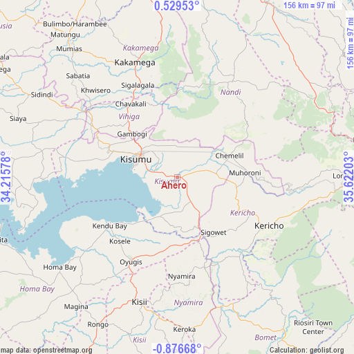
Ahero GPS coordinates[2]
0° 10' 24.924" South, 34° 55' 8.04" East
| Map corner | latitude | longitude |
|---|---|---|
| Upper-left | 0.52953°, | 34.21578° |
| Center: | -0.17359°, | 34.9189° |
| Lower-right: | -0.87668°, | 35.62203° |
| Map W x H: | 156.4×156.4 km | = 97.2×97.2mi |
| max Lat: | 3.93726° ⇑40.4% North |
| Ahero: | -0.17359° |
| min Lat: | ⇓59.6% South -4.64756° |
| min Long | Ahero | max Long |
| 33.97248° | 34.9189° | 41.85688° |
| W 21.9%⇐ | ⇒78.1% E |
Elevation
Elevation of Ahero is 1153 m = 3783 ft, and this is 193.7 m = 635 ft below average elevation for this country.
| Max E: |
2514 m = 8248 ft | 74.6% |
| Avg. | 1346.7 m = 4418 ft | |
| Ahero | 1153 m = 3783 ft | |
Min E: |
7 m = 23 ft | 25.4% |
See also: Kenya elevation on elevation.city.
Geographical zone
Ahero is located in South Torrid zone (between Equator and Tropic of Capricorn). Distance of Equator is 19.3 km =12 mi to North.| Distance of | km | miles | from Ahero |
|---|---|---|---|
| Equator | 19.3 | 12 | to North |
| Tropic Capricorn | 2586.6 | 1607.2 | to South |
| Antarctic Circle | 7381.9 | 4586.9 | to South |
| South Pole | 9987.8 | 6206.1 | to South |


Nearby cities:
15 places around Ahero: (largest is in red/bold)
• Butere
63.7 km =39.6 mi,  311°
311°
• Kakamega
54.2 km =33.7 mi,  340°
340°
• Kapsabet
46.8 km =29.1 mi,  26°
26°
• Kericho
45.9 km =28.5 mi,  118°
118°
• Kipkelion
61.1 km =38 mi,  92°
92°
• Kisii
59 km =36.7 mi,  196°
196°
• Kisumu
19.2 km =11.9 mi,  294°
294°
• Litein
54.5 km =33.9 mi,  146°
146°
• Mbale
35.9 km =22.3 mi,  322°
322°
• Muhoroni
30.9 km =19.2 mi, 86°
• Nandi Hills
42.7 km =26.5 mi,  43°
43°
• Nyamira
43.4 km =27 mi,  177°
177°
• Oyugis
42.8 km =26.6 mi,  209°
209°
• Sotik
61.3 km =38.1 mi,  159°
159°
• Yala
52 km =32.3 mi,  304°
304°
Sources, notices
• [Note1] Compared only with cities in Kenya existing in our database
• [Src1] Map data: © OpenStreetMap contributors (CC-BY-SA)
• [Src2] Other city data from geonames.org with taken over terms of usage.
• [Src3] Geographical zone / Annual Mean Temperature by Robert A. Rohde @ Wikipedia
