Kisumu geodata
Kisumu is a seat of a first-order administrative division; located in Kenya in Africa/Nairobi (GMT+3) time zone. With population of 216,479 people, there are 4 cities with bigger population in this country. Compared to other cities in Kenya, 64% of cities are located further ↓South; 80.7% of cities are located further →East and 70.2% of cities have higher elevation than Kisumu. Note1


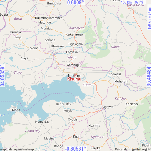
Kisumu GPS coordinates[2]
0° 6' 7.956" South, 34° 45' 42.156" East
| Map corner | latitude | longitude |
|---|---|---|
| Upper-left | 0.6009°, | 34.05859° |
| Center: | -0.10221°, | 34.76171° |
| Lower-right: | -0.80531°, | 35.46484° |
| Map W x H: | 156.4×156.4 km | = 97.2×97.2mi |
| max Lat: | 3.93726° ⇑36% North |
| Kisumu: | -0.10221° |
| min Lat: | ⇓64% South -4.64756° |
| min Long | Kisumu | max Long |
| 33.97248° | 34.76171° | 41.85688° |
| W 19.3%⇐ | ⇒80.7% E |
Elevation
Elevation of Kisumu is 1174 m = 3852 ft, and this is 172.7 m = 567 ft below average elevation for this country.
| Max E: |
2514 m = 8248 ft | 70.2% |
| Avg. | 1346.7 m = 4418 ft | |
| Kisumu | 1174 m = 3852 ft | |
Min E: |
7 m = 23 ft | 29.8% |
See also: Kisumu elevation on elevation.city.
Geographical zone
Kisumu is located in South Torrid zone (between Equator and Tropic of Capricorn). Distance of Equator is 11.4 km =7.1 mi to North.| Distance of | km | miles | from Kisumu |
|---|---|---|---|
| Equator | 11.4 | 7.1 | to North |
| Tropic Capricorn | 2594.6 | 1612.2 | to South |
| Antarctic Circle | 7389.8 | 4591.8 | to South |
| South Pole | 9995.7 | 6211 | to South |


Nearby cities:
15 places around Kisumu: (largest is in red/bold)
• Ahero
19.2 km =11.9 mi,  114°
114°
• Butere
45.8 km =28.5 mi,  318°
318°
• Homa Bay
58.1 km =36.1 mi,  215°
215°
• Kakamega
43 km =26.7 mi,  358°
358°
• Kapsabet
51.1 km =31.8 mi,  48°
48°
• Kericho
65.1 km =40.5 mi,  116°
116°
• Kisii
64.4 km =40 mi,  179°
179°
• Mbale
21 km =13 mi,  347°
347°
• Muhoroni
48.7 km =30.3 mi,  97°
97°
• Mumias
57.3 km =35.6 mi,  327°
327°
• Nandi Hills
52.3 km =32.5 mi,  64°
64°
• Nyamira
54.8 km =34.1 mi,  159°
159°
• Oyugis
45.4 km =28.2 mi, 184°
• Siaya
55.7 km =34.6 mi,  288°
288°
• Yala
33.3 km =20.7 mi,  311°
311°
Sources, notices
• [Note1] Compared only with cities in Kenya existing in our database
• [Src1] Map data: © OpenStreetMap contributors (CC-BY-SA)
• [Src2] Other city data from geonames.org with taken over terms of usage.
• [Src3] Geographical zone / Annual Mean Temperature by Robert A. Rohde @ Wikipedia
