Kisii geodata
Kisii is a seat of a first-order administrative division; located in Kenya in Africa/Nairobi (GMT+3) time zone. With population of 28,547 people, there are 36 cities with bigger population in this country. Compared to other cities in Kenya, 56.1% of cities are located further ↑North; 79.8% of cities are located further →East and 67.5% of cities have lower elevation than Kisii. Note1


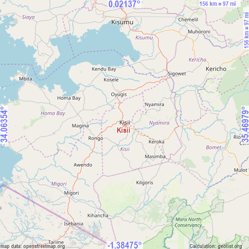
Kisii GPS coordinates[2]
0° 40' 54.264" South, 34° 45' 59.976" East
| Map corner | latitude | longitude |
|---|---|---|
| Upper-left | 0.02137°, | 34.06354° |
| Center: | -0.68174°, | 34.76666° |
| Lower-right: | -1.38475°, | 35.46979° |
| Map W x H: | 156.3×156.3 km | = 97.1×97.1mi |
| max Lat: | 3.93726° ⇑56.1% North |
| Kisii: | -0.68174° |
| min Lat: | ⇓43.9% South -4.64756° |
| min Long | Kisii | max Long |
| 33.97248° | 34.76666° | 41.85688° |
| W 20.2%⇐ | ⇒79.8% E |
Elevation
Elevation of Kisii is 1686 m = 5531 ft, and this is 339.3 m = 1113 ft above average elevation for this country.
| Max E: |
2514 m = 8248 ft | 32.5% |
| Kisii | 1686 m 5531 ft | |
| Avg. | 1346.7 m = 4418 ft | |
Min E: |
7 m = 23 ft | 67.5% |
See also: Kenya elevation on elevation.city.
Geographical zone
Kisii is located in South Torrid zone (between Equator and Tropic of Capricorn). Distance of Equator is 75.8 km =47.1 mi to North.| Distance of | km | miles | from Kisii |
|---|---|---|---|
| Equator | 75.8 | 47.1 | to North |
| Tropic Capricorn | 2530.1 | 1572.1 | to South |
| Antarctic Circle | 7325.4 | 4551.8 | to South |
| South Pole | 9931.3 | 6171 | to South |


Nearby cities:
15 places around Kisii: (largest is in red/bold)
• Ahero
59 km =36.7 mi,  16°
16°
• Homa Bay
38.5 km =23.9 mi,  296°
296°
• Kericho
67.2 km =41.8 mi,  58°
58°
• Keroka
22.6 km =14 mi,  117°
117°
• Kihancha
59.2 km =36.8 mi,  196°
196°
• Kisumu
64.4 km =40 mi,  359°
359°
• Litein
48.3 km =30 mi,  76°
76°
• Mbale
85.1 km =52.9 mi, 356°
• Migori
53.5 km =33.2 mi,  217°
217°
• Muhoroni
75.3 km =46.8 mi,  39°
39°
• Nyamira
23 km =14.3 mi, 55°
• Ogembo
14 km =8.7 mi, 198°
• Oyugis
19.5 km =12.1 mi,  348°
348°
• Sotik
38.3 km =23.8 mi,  91°
91°
• Sotik Post
64.9 km =40.3 mi,  99°
99°
Sources, notices
• [Note1] Compared only with cities in Kenya existing in our database
• [Src1] Map data: © OpenStreetMap contributors (CC-BY-SA)
• [Src2] Other city data from geonames.org with taken over terms of usage.
• [Src3] Geographical zone / Annual Mean Temperature by Robert A. Rohde @ Wikipedia
