Kericho geodata
Kericho is a seat of a first-order administrative division; located in Kenya in Africa/Nairobi (GMT+3) time zone. With population of 35,748 people, there are 27 cities with bigger population in this country. Compared to other cities in Kenya, 53.5% of cities are located further ↓South; 67.5% of cities are located further →East and 85.1% of cities have lower elevation than Kericho. Note1


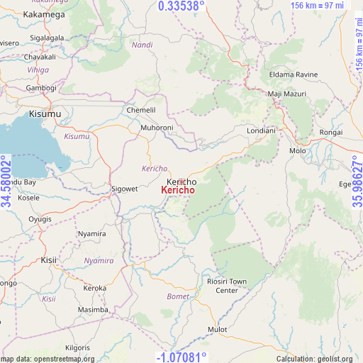
Kericho GPS coordinates[2]
0° 22' 3.864" South, 35° 16' 59.304" East
| Map corner | latitude | longitude |
|---|---|---|
| Upper-left | 0.33538°, | 34.58002° |
| Center: | -0.36774°, | 35.28314° |
| Lower-right: | -1.07081°, | 35.98627° |
| Map W x H: | 156.4×156.4 km | = 97.2×97.2mi |
| max Lat: | 3.93726° ⇑46.5% North |
| Kericho: | -0.36774° |
| min Lat: | ⇓53.5% South -4.64756° |
| min Long | Kericho | max Long |
| 33.97248° | 35.28314° | 41.85688° |
| W 32.5%⇐ | ⇒67.5% E |
Elevation
Elevation of Kericho is 2002 m = 6568 ft, and this is 655.3 m = 2150 ft above average elevation for this country.
| Max E: |
2514 m = 8248 ft | 14.9% |
| Kericho | 2002 m 6568 ft | |
| Avg. | 1346.7 m = 4418 ft | |
Min E: |
7 m = 23 ft | 85.1% |
See also: Kenya elevation on elevation.city.
Geographical zone
Kericho is located in South Torrid zone (between Equator and Tropic of Capricorn). Distance of Equator is 40.9 km =25.4 mi to North.| Distance of | km | miles | from Kericho |
|---|---|---|---|
| Equator | 40.9 | 25.4 | to North |
| Tropic Capricorn | 2565 | 1593.8 | to South |
| Antarctic Circle | 7360.3 | 4573.5 | to South |
| South Pole | 9966.2 | 6192.7 | to South |


Nearby cities:
15 places around Kericho: (largest is in red/bold)
• Ahero
45.9 km =28.5 mi,  298°
298°
• Kapsabet
66.6 km =41.4 mi,  342°
342°
• Keroka
58.8 km =36.5 mi,  219°
219°
• Kipkelion
27.7 km =17.2 mi,  47°
47°
• Kisii
67.2 km =41.8 mi,  238°
238°
• Kisumu
65.1 km =40.5 mi, 296°
• Litein
26 km =16.2 mi,  203°
203°
• Londiani
41.2 km =25.6 mi,  56°
56°
• Molo
51.6 km =32.1 mi,  75°
75°
• Muhoroni
25.2 km =15.7 mi, 337°
• Nandi Hills
53.6 km =33.3 mi,  348°
348°
• Nyamira
44.3 km =27.5 mi, 240°
• Oyugis
63.4 km =39.4 mi,  255°
255°
• Sotik
40.7 km =25.3 mi,  208°
208°
• Sotik Post
46.4 km =28.8 mi,  171°
171°
Sources, notices
• [Note1] Compared only with cities in Kenya existing in our database
• [Src1] Map data: © OpenStreetMap contributors (CC-BY-SA)
• [Src2] Other city data from geonames.org with taken over terms of usage.
• [Src3] Geographical zone / Annual Mean Temperature by Robert A. Rohde @ Wikipedia
