Kangundo geodata
Kangundo (Machakos) is a populated place; located in Kenya in Africa/Nairobi (GMT+3) time zone. With population of 10,094 people, there are 66 cities with bigger population in this country. Compared to other cities in Kenya, 75.4% of cities are located further ↑North; 70.2% of cities are located further ←West and 56.1% of cities have lower elevation than Kangundo. Note1


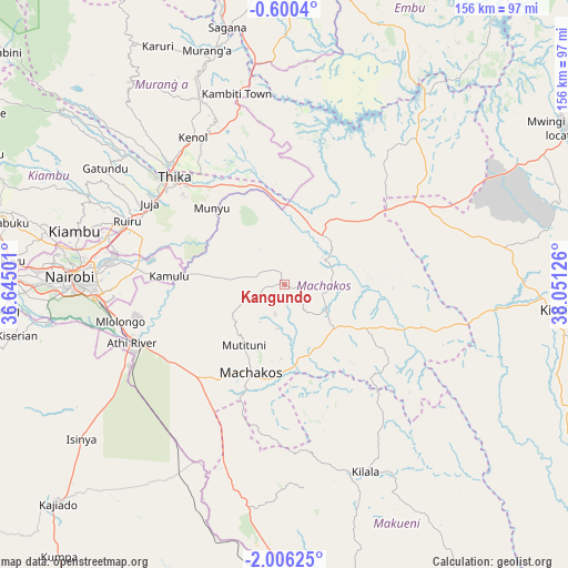
Kangundo GPS coordinates[2]
1° 18' 12.312" South, 37° 20' 53.268" East
| Map corner | latitude | longitude |
|---|---|---|
| Upper-left | -0.6004°, | 36.64501° |
| Center: | -1.30342°, | 37.34813° |
| Lower-right: | -2.00625°, | 38.05126° |
| Map W x H: | 156.3×156.3 km | = 97.1×97.1mi |
| max Lat: | 3.93726° ⇑75.4% North |
| Kangundo: | -1.30342° |
| min Lat: | ⇓24.6% South -4.64756° |
| min Long | Kangundo | max Long |
| 33.97248° | 37.34813° | 41.85688° |
| W 70.2%⇐ | ⇒29.8% E |
Elevation
Elevation of Kangundo is 1546 m = 5072 ft, and this is 199.3 m = 654 ft above average elevation for this country.
| Max E: |
2514 m = 8248 ft | 43.9% |
| Kangundo | 1546 m 5072 ft | |
| Avg. | 1346.7 m = 4418 ft | |
Min E: |
7 m = 23 ft | 56.1% |
See also: Kenya elevation on elevation.city.
Geographical zone
Kangundo is located in South Torrid zone (between Equator and Tropic of Capricorn). Distance of Equator is 144.9 km =90 mi to North.| Distance of | km | miles | from Kangundo |
|---|---|---|---|
| Equator | 144.9 | 90 | to North |
| Tropic Capricorn | 2461 | 1529.2 | to South |
| Antarctic Circle | 7256.2 | 4508.8 | to South |
| South Pole | 9862.1 | 6128 | to South |


Nearby cities:
15 places around Kangundo: (largest is in red/bold)
• Athi River
44.5 km =27.7 mi,  247°
247°
• Kandara
59.3 km =36.8 mi,  319°
319°
• Karuri
69.6 km =43.2 mi,  344°
344°
• Kiambu
58.8 km =36.5 mi,  284°
284°
• Kitui
74 km =46 mi,  95°
95°
• Konza
54.1 km =33.6 mi,  206°
206°
• Machakos
26 km =16.2 mi,  200°
200°
• Makueni Boma
63.5 km =39.5 mi,  151°
151°
• Maragua
61.3 km =38.1 mi, 337°
• Murang’a
68.3 km =42.4 mi, 341°
• Nairobi
59.1 km =36.7 mi,  272°
272°
• Pumwani
55.4 km =34.4 mi, 272°
• Sagana
72.3 km =44.9 mi,  347°
347°
• Thika
43.2 km =26.8 mi,  314°
314°
• Wote
61.6 km =38.3 mi, 149°
Sources, notices
• [Note1] Compared only with cities in Kenya existing in our database
• [Src1] Map data: © OpenStreetMap contributors (CC-BY-SA)
• [Src2] Other city data from geonames.org with taken over terms of usage.
• [Src3] Geographical zone / Annual Mean Temperature by Robert A. Rohde @ Wikipedia
