Mwingi geodata
Mwingi (Kitui) is a populated place; located in Kenya in Africa/Nairobi (GMT+3) time zone. With population of 11,219 people, there are 60 cities with bigger population in this country. Compared to other cities in Kenya, 66.7% of cities are located further ↑North; 80.7% of cities are located further ←West and 78.9% of cities have higher elevation than Mwingi. Note1


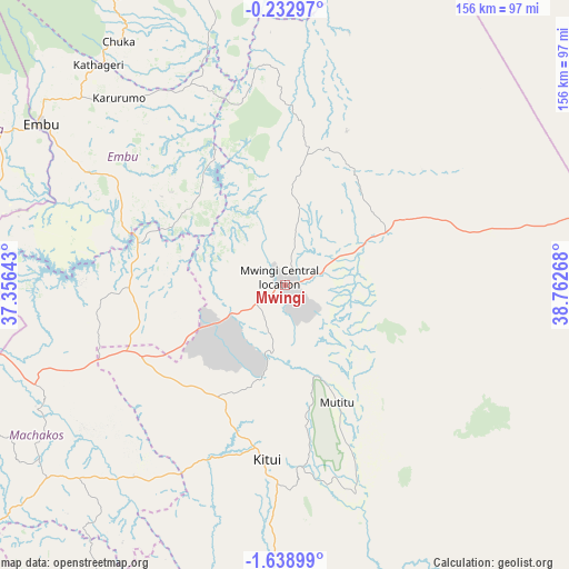
Mwingi GPS coordinates[2]
0° 56' 9.78" South, 38° 3' 34.38" East
| Map corner | latitude | longitude |
|---|---|---|
| Upper-left | -0.23297°, | 37.35643° |
| Center: | -0.93605°, | 38.05955° |
| Lower-right: | -1.63899°, | 38.76268° |
| Map W x H: | 156.3×156.3 km | = 97.1×97.1mi |
| max Lat: | 3.93726° ⇑66.7% North |
| Mwingi: | -0.93605° |
| min Lat: | ⇓33.3% South -4.64756° |
| min Long | Mwingi | max Long |
| 33.97248° | 38.05955° | 41.85688° |
| W 80.7%⇐ | ⇒19.3% E |
Elevation
Elevation of Mwingi is 947 m = 3107 ft, and this is 399.7 m = 1311 ft below average elevation for this country.
| Max E: |
2514 m = 8248 ft | 78.9% |
| Avg. | 1346.7 m = 4418 ft | |
| Mwingi | 947 m = 3107 ft | |
Min E: |
7 m = 23 ft | 21.1% |
See also: Kenya elevation on elevation.city.
Geographical zone
Mwingi is located in South Torrid zone (between Equator and Tropic of Capricorn). Distance of Equator is 104.1 km =64.7 mi to North.| Distance of | km | miles | from Mwingi |
|---|---|---|---|
| Equator | 104.1 | 64.7 | to North |
| Tropic Capricorn | 2501.8 | 1554.5 | to South |
| Antarctic Circle | 7297.1 | 4534.2 | to South |
| South Pole | 9903 | 6153.4 | to South |


Nearby cities:
15 places around Mwingi: (largest is in red/bold)
• Chuka
81.3 km =50.5 mi,  325°
325°
• Embu
80.1 km =49.8 mi,  303°
303°
• Kandara
117.6 km =73.1 mi,  272°
272°
• Kangundo
89 km =55.3 mi,  242°
242°
• Karuri
100.9 km =62.7 mi,  285°
285°
• Kathwana
70.5 km =43.8 mi,  342°
342°
• Kerugoya
99.3 km =61.7 mi, 299°
• Kitui
48.2 km =30 mi,  186°
186°
• Machakos
109.8 km =68.2 mi,  233°
233°
• Makueni Boma
108 km =67.1 mi,  206°
206°
• Maragua
104.2 km =64.7 mi,  278°
278°
• Murang’a
103.6 km =64.4 mi, 283°
• Sagana
99.2 km =61.6 mi, 287°
• Thika
110.6 km =68.7 mi,  264°
264°
• Wote
105.4 km =65.5 mi, 207°
Sources, notices
• [Note1] Compared only with cities in Kenya existing in our database
• [Src1] Map data: © OpenStreetMap contributors (CC-BY-SA)
• [Src2] Other city data from geonames.org with taken over terms of usage.
• [Src3] Geographical zone / Annual Mean Temperature by Robert A. Rohde @ Wikipedia
