Nandi Hills geodata
Nandi Hills (Nandi) is a populated place; located in Kenya in Africa/Nairobi (GMT+3) time zone. With population of 4,257 people, there are 94 cities with bigger population in this country. Compared to other cities in Kenya, 71.9% of cities are located further ↓South; 71.9% of cities are located further →East and 81.6% of cities have lower elevation than Nandi Hills. Note1


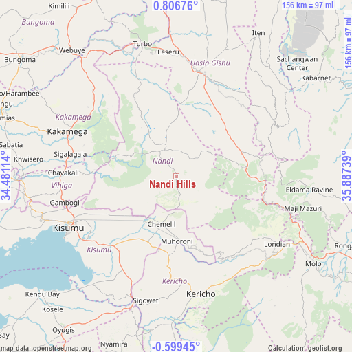
Nandi Hills GPS coordinates[2]
0° 6' 13.176" North, 35° 11' 3.336" East
| Map corner | latitude | longitude |
|---|---|---|
| Upper-left | 0.80676°, | 34.48114° |
| Center: | 0.10366°, | 35.18426° |
| Lower-right: | -0.59945°, | 35.88739° |
| Map W x H: | 156.4×156.4 km | = 97.2×97.2mi |
| max Lat: | 3.93726° ⇑28.1% North |
| Nandi Hills: | 0.10366° |
| min Lat: | ⇓71.9% South -4.64756° |
| min Long | Nandi Hills | max Long |
| 33.97248° | 35.18426° | 41.85688° |
| W 28.1%⇐ | ⇒71.9% E |
Elevation
Elevation of Nandi Hills is 1987 m = 6519 ft, and this is 640.3 m = 2101 ft above average elevation for this country.
| Max E: |
2514 m = 8248 ft | 18.4% |
| Nandi Hills | 1987 m 6519 ft | |
| Avg. | 1346.7 m = 4418 ft | |
Min E: |
7 m = 23 ft | 81.6% |
See also: Kenya elevation on elevation.city.
Geographical zone
Nandi Hills is located in North Torrid zone (between Equator and Tropic of Cancer). Distance of Equator is 11.5 km =7.1 mi to South.| Distance of | km | miles | from Nandi Hills |
|---|---|---|---|
| North Pole | 9995.5 | 6210.9 | to North |
| Arctic Circle | 7389.6 | 4591.7 | to North |
| Tropic Cancer | 2594.4 | 1612.1 | to North |
| Equator | 11.5 | 7.1 | to South |


Nearby cities:
15 places around Nandi Hills: (largest is in red/bold)
• Ahero
42.7 km =26.5 mi,  223°
223°
• Eldama Ravine
60.7 km =37.7 mi,  95°
95°
• Eldoret
47.3 km =29.4 mi,  11°
11°
• Iten
72.6 km =45.1 mi,  29°
29°
• Kakamega
52.1 km =32.4 mi,  292°
292°
• Kapsabet
14.2 km =8.8 mi,  321°
321°
• Kericho
53.6 km =33.3 mi,  168°
168°
• Kipkelion
46.1 km =28.6 mi,  136°
136°
• Kisumu
52.3 km =32.5 mi,  244°
244°
• Londiani
54.5 km =33.9 mi,  123°
123°
• Mbale
51.5 km =32 mi,  267°
267°
• Molo
72.4 km =45 mi, 122°
• Muhoroni
29.1 km =18.1 mi,  177°
177°
• Webuye
71.8 km =44.6 mi, 320°
• Yala
72.1 km =44.8 mi, 269°
Sources, notices
• [Note1] Compared only with cities in Kenya existing in our database
• [Src1] Map data: © OpenStreetMap contributors (CC-BY-SA)
• [Src2] Other city data from geonames.org with taken over terms of usage.
• [Src3] Geographical zone / Annual Mean Temperature by Robert A. Rohde @ Wikipedia
