Garissa geodata
Garissa is a seat of a first-order administrative division; located in Kenya in Africa/Nairobi (GMT+3) time zone. With population of 67,861 people, there are 8 cities with bigger population in this country. Compared to other cities in Kenya, 51.8% of cities are located further ↓South; 91.2% of cities are located further ←West and 90.4% of cities have higher elevation than Garissa. Note1


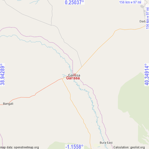
Garissa GPS coordinates[2]
0° 27' 9.9" South, 39° 38' 45.636" East
| Map corner | latitude | longitude |
|---|---|---|
| Upper-left | 0.25037°, | 38.94289° |
| Center: | -0.45275°, | 39.64601° |
| Lower-right: | -1.1558°, | 40.34914° |
| Map W x H: | 156.4×156.4 km | = 97.2×97.2mi |
| max Lat: | 3.93726° ⇑48.2% North |
| Garissa: | -0.45275° |
| min Lat: | ⇓51.8% South -4.64756° |
| min Long | Garissa | max Long |
| 33.97248° | 39.64601° | 41.85688° |
| W 91.2%⇐ | ⇒8.8% E |
Elevation
Elevation of Garissa is 147 m = 482 ft, and this is 1199.7 m = 3936 ft below average elevation for this country.
| Max E: |
2514 m = 8248 ft | 90.4% |
| Avg. | 1346.7 m = 4418 ft | |
| Garissa | 147 m = 482 ft | |
Min E: |
7 m = 23 ft | 9.6% |
See also: Garissa elevation on elevation.city.
Geographical zone
Garissa is located in South Torrid zone (between Equator and Tropic of Capricorn). Distance of Equator is 50.3 km =31.3 mi to North.| Distance of | km | miles | from Garissa |
|---|---|---|---|
| Equator | 50.3 | 31.3 | to North |
| Tropic Capricorn | 2555.6 | 1588 | to South |
| Antarctic Circle | 7350.8 | 4567.6 | to South |
| South Pole | 9956.7 | 6186.8 | to South |


Nearby cities:
15 places around Garissa: (largest is in red/bold)
• Chuka
222.8 km =138.4 mi,  273°
273°
• Embu
243.5 km =151.3 mi, 267°
• Hola
122.3 km =76 mi,  159°
159°
• Isiolo
246.4 km =153.1 mi,  291°
291°
• Kathwana
198.1 km =123.1 mi, 273°
• Kerugoya
263.1 km =163.5 mi, 268°
• Kipini
250.4 km =155.6 mi, 157°
• Kitui
208.3 km =129.4 mi,  240°
240°
• Lamu
245.8 km =152.7 mi,  145°
145°
• Maua
204.4 km =127 mi, 291°
• Meru
228.1 km =141.7 mi,  284°
284°
• Mwingi
184.4 km =114.6 mi,  253°
253°
• Wajir
248.8 km =154.6 mi,  10°
10°
• Witu
232.6 km =144.5 mi, 157°
• Wote
268.5 km =166.8 mi, 236°
Sources, notices
• [Note1] Compared only with cities in Kenya existing in our database
• [Src1] Map data: © OpenStreetMap contributors (CC-BY-SA)
• [Src2] Other city data from geonames.org with taken over terms of usage.
• [Src3] Geographical zone / Annual Mean Temperature by Robert A. Rohde @ Wikipedia
