Hola geodata
Hola (Tana River) is a seat of a first-order administrative division; located in Kenya in Africa/Nairobi (GMT+3) time zone. With population of 6,932 people, there are 78 cities with bigger population in this country. Compared to other cities in Kenya, 78.9% of cities are located further ↑North; 94.7% of cities are located further ←West and 91.2% of cities have higher elevation than Hola. Note1


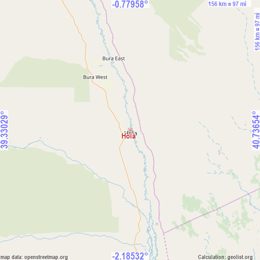
Hola GPS coordinates[2]
1° 28' 57.216" South, 40° 2' 0.276" East
| Map corner | latitude | longitude |
|---|---|---|
| Upper-left | -0.77958°, | 39.33029° |
| Center: | -1.48256°, | 40.03341° |
| Lower-right: | -2.18532°, | 40.73654° |
| Map W x H: | 156.3×156.3 km | = 97.1×97.1mi |
| max Lat: | 3.93726° ⇑78.9% North |
| Hola: | -1.48256° |
| min Lat: | ⇓21.1% South -4.64756° |
| min Long | Hola | max Long |
| 33.97248° | 40.03341° | 41.85688° |
| W 94.7%⇐ | ⇒5.3% E |
Elevation
Elevation of Hola is 65 m = 213 ft, and this is 1281.7 m = 4205 ft below average elevation for this country.
| Max E: |
2514 m = 8248 ft | 91.2% |
| Avg. | 1346.7 m = 4418 ft | |
| Hola | 65 m = 213 ft | |
Min E: |
7 m = 23 ft | 8.8% |
See also: Kenya elevation on elevation.city.
Geographical zone
Hola is located in South Torrid zone (between Equator and Tropic of Capricorn). Distance of Equator is 164.8 km =102.4 mi to North.| Distance of | km | miles | from Hola |
|---|---|---|---|
| Equator | 164.8 | 102.4 | to North |
| Tropic Capricorn | 2441.1 | 1516.8 | to South |
| Antarctic Circle | 7236.3 | 4496.4 | to South |
| South Pole | 9842.2 | 6115.7 | to South |


Nearby cities:
15 places around Hola: (largest is in red/bold)
• Garissa
122.3 km =76 mi,  339°
339°
• Kathwana
272.6 km =169.4 mi,  298°
298°
• Kilifi
239.7 km =148.9 mi,  184°
184°
• Kipini
128.3 km =79.7 mi,  154°
154°
• Kitui
225.2 km =139.9 mi,  273°
273°
• Lamu
130.4 km =81 mi,  132°
132°
• Makueni Boma
270.2 km =167.9 mi,  262°
262°
• Malindi
193.2 km =120 mi, 177°
• Mariakani
271.8 km =168.9 mi,  193°
193°
• Mtito Andei
247.1 km =153.5 mi,  237°
237°
• Mwingi
227.7 km =141.5 mi,  285°
285°
• Takaungu
245.5 km =152.5 mi, 184°
• Voi
268.7 km =167 mi,  217°
217°
• Witu
110.4 km =68.6 mi,  155°
155°
• Wote
269.3 km =167.3 mi, 262°
Sources, notices
• [Note1] Compared only with cities in Kenya existing in our database
• [Src1] Map data: © OpenStreetMap contributors (CC-BY-SA)
• [Src2] Other city data from geonames.org with taken over terms of usage.
• [Src3] Geographical zone / Annual Mean Temperature by Robert A. Rohde @ Wikipedia
