Wŏnsan geodata
Wŏnsan (Kangwŏn-do) is a seat of a first-order administrative division; located in North Korea in Asia/Pyongyang (GMT+9) time zone. With population of 329,207 people, there are 6 cities with bigger population in this country. Compared to other cities in North Korea, 72.5% of cities are located further ↑North; 51.6% of cities are located further ←West and 90.1% of cities have higher elevation than Wŏnsan. Note1


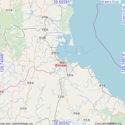
Wŏnsan GPS coordinates[2]
39° 9' 10.008" North, 127° 26' 36.996" East
| Map corner | latitude | longitude |
|---|---|---|
| Upper-left | 39.69591°, | 126.74049° |
| Center: | 39.15278°, | 127.44361° |
| Lower-right: | 38.60542°, | 128.14674° |
| Map W x H: | 121.3×121.3 km | = 75.4×75.4mi |
| max Lat: | 42.95722° ⇑72.5% North |
| Wŏnsan: | 39.15278° |
| min Lat: | ⇓27.5% South 37.90889° |
| min Long | Wŏnsan | max Long |
| 124.39806° | 127.44361° | 130.49522° |
| W 51.6%⇐ | ⇒48.4% E |
Elevation
Elevation of Wŏnsan is 7 m = 23 ft, and this is 124.7 m = 409 ft below average elevation for this country.
| Max E: |
1466 m = 4810 ft | 90.1% |
| Avg. | 131.7 m = 432 ft | |
| Wŏnsan | 7 m = 23 ft | |
Min E: |
1 m = 3 ft | 9.9% |
See also: Wŏnsan elevation on elevation.city.
Geographical zone
Wŏnsan is located in North temperate zone (between Tropic of Cancer and the Arctic Circle). Distance of this Northern Tropic circle is 1747.5 km =1085.8 mi to South.| Distance of | km | miles | from Wŏnsan |
|---|---|---|---|
| North Pole | 5653.7 | 3513 | to North |
| Arctic Circle | 3047.8 | 1893.8 | to North |
| Tropic Cancer | 1747.5 | 1085.8 | to South |
| Equator | 4353.4 | 2705.1 | to South |


Nearby cities:
15 places around Wŏnsan: (largest is in red/bold)
• Anbyŏn-ŭp
14.1 km =8.8 mi,  150°
150°
• Hamhŭng
85.5 km =53.1 mi,  5°
5°
• Hoeyang
51 km =31.7 mi,  164°
164°
• Hongwŏn
106.5 km =66.2 mi,  24°
24°
• Hŭngnam
77 km =47.8 mi, 11°
• Kangdong-ŭp
116.2 km =72.2 mi,  269°
269°
• Koksan
78.8 km =49 mi,  238°
238°
• Kosan
33.1 km =20.6 mi,  183°
183°
• Kowŏn-ŭp
36.1 km =22.4 mi,  331°
331°
• Samho-rodongjagu
95.7 km =59.5 mi, 22°
• Sangsŏng-ni
48.1 km =29.9 mi, 272°
• Sinsang-ni
55.4 km =34.4 mi,  356°
356°
• T’ongch’ŏn-ŭp
44.6 km =27.7 mi,  119°
119°
• Yuktae-dong
114.7 km =71.3 mi,  32°
32°
• Yŏnggwang-ŭp
96.2 km =59.8 mi,  0°
0°
Sources, notices
• [Note1] Compared only with cities in North Korea existing in our database
• [Src1] Map data: © OpenStreetMap contributors (CC-BY-SA)
• [Src2] Other city data from geonames.org with taken over terms of usage.
• [Src3] Geographical zone / Annual Mean Temperature by Robert A. Rohde @ Wikipedia
