Hongwŏn geodata
Hongwŏn (Hamgyŏng-namdo) is a populated place; located in North Korea in Asia/Pyongyang (GMT+9) time zone. With population of 70,923 people, there are 18 cities with bigger population in this country. Compared to other cities in North Korea, 51.6% of cities are located further ↓South; 60.4% of cities are located further ←West and 59.3% of cities have higher elevation than Hongwŏn. Note1


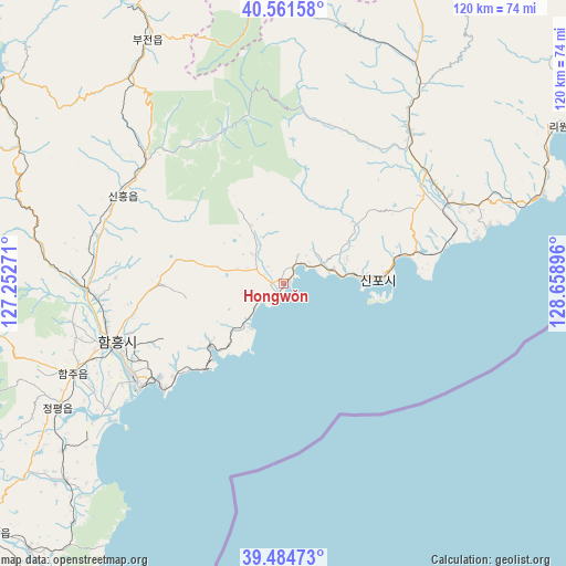
Hongwŏn GPS coordinates[2]
40° 1' 31.008" North, 127° 57' 20.988" East
| Map corner | latitude | longitude |
|---|---|---|
| Upper-left | 40.56158°, | 127.25271° |
| Center: | 40.02528°, | 127.95583° |
| Lower-right: | 39.48473°, | 128.65896° |
| Map W x H: | 119.7×119.7 km | = 74.4×74.4mi |
| max Lat: | 42.95722° ⇑48.4% North |
| Hongwŏn: | 40.02528° |
| min Lat: | ⇓51.6% South 37.90889° |
| min Long | Hongwŏn | max Long |
| 124.39806° | 127.95583° | 130.49522° |
| W 60.4%⇐ | ⇒39.6% E |
Elevation
Elevation of Hongwŏn is 29 m = 95 ft, and this is 102.7 m = 337 ft below average elevation for this country.
| Max E: |
1466 m = 4810 ft | 59.3% |
| Avg. | 131.7 m = 432 ft | |
| Hongwŏn | 29 m = 95 ft | |
Min E: |
1 m = 3 ft | 40.7% |
See also: Hongwŏn elevation on elevation.city.
Geographical zone
Hongwŏn is located in North temperate zone (between Tropic of Cancer and the Arctic Circle). Distance of this Northern Tropic circle is 1844.5 km =1146.1 mi to South.| Distance of | km | miles | from Hongwŏn |
|---|---|---|---|
| North Pole | 5556.7 | 3452.8 | to North |
| Arctic Circle | 2950.8 | 1833.5 | to North |
| Tropic Cancer | 1844.5 | 1146.1 | to South |
| Equator | 4450.4 | 2765.3 | to South |


Nearby cities:
15 places around Hongwŏn: (largest is in red/bold)
• Anbyŏn-ŭp
115.4 km =71.7 mi,  198°
198°
• Hamhŭng
37.7 km =23.4 mi,  251°
251°
• Hŭngnam
35.9 km =22.3 mi,  233°
233°
• Iwŏn-ŭp
68 km =42.3 mi,  60°
60°
• Kapsan-ŭp
121.8 km =75.7 mi,  13°
13°
• Kimch’aek-si
126.7 km =78.7 mi, 55°
• Kosan
138 km =85.7 mi, 199°
• Kowŏn-ŭp
89.3 km =55.5 mi,  223°
223°
• Samho-rodongjagu
11.3 km =7 mi, 219°
• Sangsŏng-ni
132.1 km =82.1 mi, 223°
• Sinsang-ni
62.8 km =39 mi, 228°
• T’ongch’ŏn-ŭp
119.3 km =74.1 mi,  182°
182°
• Wŏnsan
106.5 km =66.2 mi, 204°
• Yuktae-dong
17.4 km =10.8 mi,  90°
90°
• Yŏnggwang-ŭp
42.7 km =26.5 mi,  268°
268°
Sources, notices
• [Note1] Compared only with cities in North Korea existing in our database
• [Src1] Map data: © OpenStreetMap contributors (CC-BY-SA)
• [Src2] Other city data from geonames.org with taken over terms of usage.
• [Src3] Geographical zone / Annual Mean Temperature by Robert A. Rohde @ Wikipedia
