Ŭiju geodata
Ŭiju (P'yŏngan-bukto) is a populated place; located in North Korea in Asia/Pyongyang (GMT+9) time zone. With population of 50,081 people, there are 24 cities with bigger population in this country. Compared to other cities in North Korea, 53.8% of cities are located further ↓South; 98.9% of cities are located further →East and 61.5% of cities have higher elevation than Ŭiju. Note1


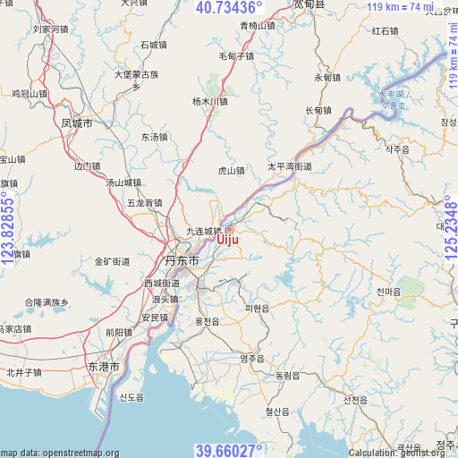
Ŭiju GPS coordinates[2]
40° 11' 57.984" North, 124° 31' 54.012" East
| Map corner | latitude | longitude |
|---|---|---|
| Upper-left | 40.73436°, | 123.82855° |
| Center: | 40.19944°, | 124.53167° |
| Lower-right: | 39.66027°, | 125.2348° |
| Map W x H: | 119.4×119.4 km | = 74.2×74.2mi |
| max Lat: | 42.95722° ⇑46.2% North |
| Ŭiju: | 40.19944° |
| min Lat: | ⇓53.8% South 37.90889° |
| min Long | Ŭiju | max Long |
| 124.39806° | 124.53167° | 130.49522° |
| W 1.1%⇐ | ⇒98.9% E |
Elevation
Elevation of Ŭiju is 26 m = 85 ft, and this is 105.7 m = 347 ft below average elevation for this country.
| Max E: |
1466 m = 4810 ft | 61.5% |
| Avg. | 131.7 m = 432 ft | |
| Ŭiju | 26 m = 85 ft | |
Min E: |
1 m = 3 ft | 38.5% |
See also: Ŭiju elevation on elevation.city.
Geographical zone
Ŭiju is located in North temperate zone (between Tropic of Cancer and the Arctic Circle). Distance of this Northern Tropic circle is 1863.8 km =1158.1 mi to South.| Distance of | km | miles | from Ŭiju |
|---|---|---|---|
| North Pole | 5537.3 | 3440.7 | to North |
| Arctic Circle | 2931.4 | 1821.5 | to North |
| Tropic Cancer | 1863.8 | 1158.1 | to South |
| Equator | 4469.8 | 2777.4 | to South |


Nearby cities:
15 places around Ŭiju: (largest is in red/bold)
• Anju
116.3 km =72.3 mi,  123°
123°
• Chŏngju
80.7 km =50.1 mi,  134°
134°
• Kujang-ŭp
132.8 km =82.5 mi,  106°
106°
• Kusŏng
65.3 km =40.6 mi, 111°
• Kwaksan
73.8 km =45.9 mi,  140°
140°
• Panghyŏn-dong
69.7 km =43.3 mi, 119°
• Pukchil-lodongjagu
103.3 km =64.2 mi,  89°
89°
• Sakchu-ŭp
48.5 km =30.1 mi,  64°
64°
• Sil-li
112.3 km =69.8 mi, 134°
• Sinanju
113.7 km =70.6 mi, 126°
• Sinŭiju
15.8 km =9.8 mi,  225°
225°
• Sunan
149 km =92.6 mi, 138°
• Sunch’ŏn
147 km =91.3 mi, 125°
• Yŏmju-ŭp
34.5 km =21.4 mi,  170°
170°
• Yŏngbyŏn
116.6 km =72.5 mi, 111°
Sources, notices
• [Note1] Compared only with cities in North Korea existing in our database
• [Src1] Map data: © OpenStreetMap contributors (CC-BY-SA)
• [Src2] Other city data from geonames.org with taken over terms of usage.
• [Src3] Geographical zone / Annual Mean Temperature by Robert A. Rohde @ Wikipedia
