Gujeong geodata
Gujeong (Gangwon-do) is a seat of a third-order administrative division; located in South Korea in Asia/Seoul (GMT+9) time zone. In our database, there are 128 cities with bigger population. Compared to other cities in South Korea, 87.8% of cities are located further ↓South; 91.3% of cities are located further ←West and 54.5% of cities have lower elevation than Gujeong. Note1


Gujeong GPS coordinates[2]
37° 43' 8.544" North, 128° 52' 47.64" East
| Map corner | latitude | longitude |
|---|---|---|
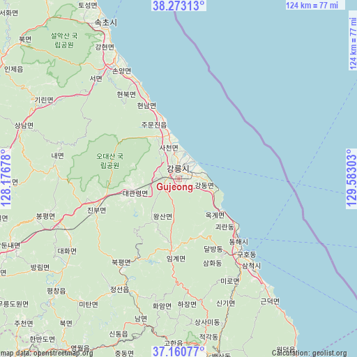
| Upper-left | 38.27313°, | 128.17678° |
| Center: | 37.71904°, | 128.8799° |
| Lower-right: | 37.16077°, | 129.58303° |
| Map W x H: | 123.7×123.7 km | = 76.9×76.9mi |
| max Lat: | 38.37881° ⇑12.2% North |
| Gujeong: | 37.71904° |
| min Lat: | ⇓87.8% South 33.25333° |
| min Long | Gujeong | max Long |
| 126.10863° | 128.8799° | 129.55377° |
| W 91.3%⇐ | ⇒8.7% E |
Elevation
Elevation of Gujeong is 48 m = 157 ft, and this is 22.4 m = 73 ft below average elevation for this country.
| Max E: |
691 m = 2267 ft | 45.5% |
| Avg. | 70.4 m = 231 ft | |
| Gujeong | 48 m = 157 ft | |
Min E: |
1 m = 3 ft | 54.5% |
See also: South Korea elevation on elevation.city.
Geographical zone
Gujeong is located in North temperate zone (between Tropic of Cancer and the Arctic Circle). Distance of this Northern Tropic circle is 1588 km =986.7 mi to South.| Distance of | km | miles | from Gujeong |
|---|---|---|---|
| North Pole | 5813.1 | 3612.1 | to North |
| Arctic Circle | 3207.2 | 1992.9 | to North |
| Tropic Cancer | 1588 | 986.7 | to South |
| Equator | 4194 | 2606 | to South |


Nearby cities:
15 places around Gujeong: (largest is in red/bold)
• Dongmyeon
90.9 km =56.5 mi,  306°
306°
• Gangdong
6.6 km =4.1 mi,  80°
80°
• Gangneung
3.8 km =2.4 mi,  349°
349°
• Haean
90.6 km =56.3 mi, 314°
• Hongch’ŏn
87.5 km =54.4 mi,  268°
268°
• Kosong
81.8 km =50.8 mi,  333°
333°
• Neietsu
69.7 km =43.3 mi,  211°
211°
• Pyeongchang
57.8 km =35.9 mi,  227°
227°
• Santyoku
40.2 km =25 mi,  140°
140°
• Seoseok
60.9 km =37.8 mi, 269°
• Sokcho
59.8 km =37.2 mi,  335°
335°
• Tonghae
27.9 km =17.3 mi,  134°
134°
• Toseong
66 km =41 mi, 334°
• T’aebaek
61.2 km =38 mi,  170°
170°
• Yanggu
89.2 km =55.4 mi,  298°
298°
Sources, notices
• [Note1] Compared only with cities in South Korea existing in our database
• [Src1] Map data: © OpenStreetMap contributors (CC-BY-SA)
• [Src2] Other city data from geonames.org with taken over terms of usage.
• [Src3] Geographical zone / Annual Mean Temperature by Robert A. Rohde @ Wikipedia
