Gangneung geodata
Gangneung (Gangwon-do) is a seat of a third-order administrative division; located in South Korea in Asia/Seoul (GMT+9) time zone. With population of 180,611 people, there are 36 cities with bigger population in this country. Compared to other cities in South Korea, 90.2% of cities are located further ↓South; 90.9% of cities are located further ←West and 50% of cities have lower elevation than Gangneung. Note1


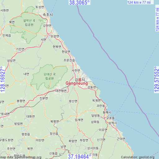
Gangneung GPS coordinates[2]
37° 45' 9.576" North, 128° 52' 20.604" East
| Map corner | latitude | longitude |
|---|---|---|
| Upper-left | 38.3065°, | 128.16927° |
| Center: | 37.75266°, | 128.87239° |
| Lower-right: | 37.19464°, | 129.57552° |
| Map W x H: | 123.6×123.6 km | = 76.8×76.8mi |
| max Lat: | 38.37881° ⇑9.8% North |
| Gangneung: | 37.75266° |
| min Lat: | ⇓90.2% South 33.25333° |
| min Long | Gangneung | max Long |
| 126.10863° | 128.87239° | 129.55377° |
| W 90.9%⇐ | ⇒9.1% E |
Elevation
Elevation of Gangneung is 42 m = 138 ft, and this is 28.4 m = 93 ft below average elevation for this country.
| Max E: |
691 m = 2267 ft | 50% |
| Avg. | 70.4 m = 231 ft | |
| Gangneung | 42 m = 138 ft | |
Min E: |
1 m = 3 ft | 50% |
See also: Gangneung elevation on elevation.city.
Geographical zone
Gangneung is located in North temperate zone (between Tropic of Cancer and the Arctic Circle). Distance of this Northern Tropic circle is 1591.8 km =989.1 mi to South.| Distance of | km | miles | from Gangneung |
|---|---|---|---|
| North Pole | 5809.4 | 3609.8 | to North |
| Arctic Circle | 3203.5 | 1990.6 | to North |
| Tropic Cancer | 1591.8 | 989.1 | to South |
| Equator | 4197.7 | 2608.3 | to South |


Nearby cities:
15 places around Gangneung: (largest is in red/bold)
• Dongmyeon
88.1 km =54.7 mi,  304°
304°
• Gangdong
7.7 km =4.8 mi,  110°
110°
• Gujeong
3.8 km =2.4 mi,  169°
169°
• Haean
87.5 km =54.4 mi,  312°
312°
• Hongch’ŏn
87 km =54.1 mi,  265°
265°
• Kosong
78.1 km =48.5 mi,  333°
333°
• Neietsu
72.6 km =45.1 mi,  209°
209°
• Pyeongchang
59.9 km =37.2 mi,  224°
224°
• Santyoku
43.5 km =27 mi,  142°
142°
• Seoseok
60.4 km =37.5 mi, 265°
• Sokcho
56.2 km =34.9 mi, 334°
• Tonghae
31.1 km =19.3 mi, 138°
• Toseong
62.4 km =38.8 mi, 333°
• T’aebaek
64.9 km =40.3 mi, 170°
• Yanggu
86.8 km =53.9 mi, 296°
Sources, notices
• [Note1] Compared only with cities in South Korea existing in our database
• [Src1] Map data: © OpenStreetMap contributors (CC-BY-SA)
• [Src2] Other city data from geonames.org with taken over terms of usage.
• [Src3] Geographical zone / Annual Mean Temperature by Robert A. Rohde @ Wikipedia
