Gangdong geodata
Gangdong (Gangwon-do) is a seat of a third-order administrative division; located in South Korea in Asia/Seoul (GMT+9) time zone. In our database, there are 128 cities with bigger population. Compared to other cities in South Korea, 88.8% of cities are located further ↓South; 92.3% of cities are located further ←West and 71% of cities have higher elevation than Gangdong. Note1


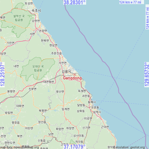
Gangdong GPS coordinates[2]
37° 43' 44.364" North, 128° 57' 15.084" East
| Map corner | latitude | longitude |
|---|---|---|
| Upper-left | 38.28301°, | 128.25107° |
| Center: | 37.72899°, | 128.95419° |
| Lower-right: | 37.17079°, | 129.65732° |
| Map W x H: | 123.7×123.7 km | = 76.9×76.9mi |
| max Lat: | 38.37881° ⇑11.2% North |
| Gangdong: | 37.72899° |
| min Lat: | ⇓88.8% South 33.25333° |
| min Long | Gangdong | max Long |
| 126.10863° | 128.95419° | 129.55377° |
| W 92.3%⇐ | ⇒7.7% E |
Elevation
Elevation of Gangdong is 21 m = 69 ft, and this is 49.4 m = 162 ft below average elevation for this country.
| Max E: |
691 m = 2267 ft | 71% |
| Avg. | 70.4 m = 231 ft | |
| Gangdong | 21 m = 69 ft | |
Min E: |
1 m = 3 ft | 29% |
See also: South Korea elevation on elevation.city.
Geographical zone
Gangdong is located in North temperate zone (between Tropic of Cancer and the Arctic Circle). Distance of this Northern Tropic circle is 1589.2 km =987.5 mi to South.| Distance of | km | miles | from Gangdong |
|---|---|---|---|
| North Pole | 5812 | 3611.4 | to North |
| Arctic Circle | 3206.1 | 1992.2 | to North |
| Tropic Cancer | 1589.2 | 987.5 | to South |
| Equator | 4195.1 | 2606.7 | to South |


Nearby cities:
15 places around Gangdong: (largest is in red/bold)
• Dongmyeon
95.6 km =59.4 mi,  303°
303°
• Gangneung
7.7 km =4.8 mi,  290°
290°
• Gujeong
6.6 km =4.1 mi,  260°
260°
• Haean
94.6 km =58.8 mi,  310°
310°
• Hongch’ŏn
94.1 km =58.5 mi,  267°
267°
• Kosong
83.9 km =52.1 mi,  329°
329°
• Neietsu
74.2 km =46.1 mi,  215°
215°
• Pyeongchang
63.5 km =39.5 mi,  231°
231°
• Santyoku
37.3 km =23.2 mi,  149°
149°
• Seoseok
67.5 km =41.9 mi, 268°
• Sokcho
61.9 km =38.5 mi, 329°
• Tonghae
24.6 km =15.3 mi, 146°
• Toseong
68.1 km =42.3 mi, 329°
• T’aebaek
61.6 km =38.3 mi,  177°
177°
• Yanggu
94.4 km =58.7 mi, 296°
Sources, notices
• [Note1] Compared only with cities in South Korea existing in our database
• [Src1] Map data: © OpenStreetMap contributors (CC-BY-SA)
• [Src2] Other city data from geonames.org with taken over terms of usage.
• [Src3] Geographical zone / Annual Mean Temperature by Robert A. Rohde @ Wikipedia
