Tonghae geodata
Tonghae (Gangwon-do) is a populated place; located in South Korea in Asia/Seoul (GMT+9) time zone. With population of 101,128 people, there are 47 cities with bigger population in this country. Compared to other cities in South Korea, 81.5% of cities are located further ↓South; 94.4% of cities are located further ←West and 66.4% of cities have higher elevation than Tonghae. Note1


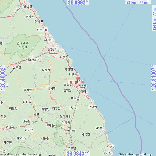
Tonghae GPS coordinates[2]
37° 32' 38.004" North, 129° 6' 24.984" East
| Map corner | latitude | longitude |
|---|---|---|
| Upper-left | 38.0993°, | 128.40382° |
| Center: | 37.54389°, | 129.10694° |
| Lower-right: | 36.98431°, | 129.81007° |
| Map W x H: | 124×124 km | = 77.1×77.1mi |
| max Lat: | 38.37881° ⇑18.5% North |
| Tonghae: | 37.54389° |
| min Lat: | ⇓81.5% South 33.25333° |
| min Long | Tonghae | max Long |
| 126.10863° | 129.10694° | 129.55377° |
| W 94.4%⇐ | ⇒5.6% E |
Elevation
Elevation of Tonghae is 24 m = 79 ft, and this is 46.4 m = 152 ft below average elevation for this country.
| Max E: |
691 m = 2267 ft | 66.4% |
| Avg. | 70.4 m = 231 ft | |
| Tonghae | 24 m = 79 ft | |
Min E: |
1 m = 3 ft | 33.6% |
See also: Tonghae elevation on elevation.city.
Geographical zone
Tonghae is located in North temperate zone (between Tropic of Cancer and the Arctic Circle). Distance of this Northern Tropic circle is 1568.6 km =974.7 mi to South.| Distance of | km | miles | from Tonghae |
|---|---|---|---|
| North Pole | 5832.6 | 3624.2 | to North |
| Arctic Circle | 3226.7 | 2005 | to North |
| Tropic Cancer | 1568.6 | 974.7 | to South |
| Equator | 4174.5 | 2593.9 | to South |


Nearby cities:
15 places around Tonghae: (largest is in red/bold)
• Andong
113.9 km =70.8 mi,  197°
197°
• Eisen
90.7 km =56.4 mi,  207°
207°
• Gangdong
24.6 km =15.3 mi,  326°
326°
• Gangneung
31.1 km =19.3 mi,  318°
318°
• Gujeong
27.9 km =17.3 mi,  314°
314°
• Hongch’ŏn
108.8 km =67.6 mi,  278°
278°
• Kosong
108.4 km =67.4 mi, 328°
• Neietsu
69.2 km =43 mi,  234°
234°
• Pyeongchang
65.9 km =40.9 mi,  252°
252°
• Santyoku
12.8 km =8 mi,  153°
153°
• Seoseok
83.1 km =51.6 mi, 282°
• Sokcho
86.5 km =53.7 mi, 328°
• Toseong
92.7 km =57.6 mi, 328°
• T’aebaek
42.2 km =26.2 mi,  194°
194°
• Wŏnju
104.8 km =65.1 mi,  258°
258°
Sources, notices
• [Note1] Compared only with cities in South Korea existing in our database
• [Src1] Map data: © OpenStreetMap contributors (CC-BY-SA)
• [Src2] Other city data from geonames.org with taken over terms of usage.
• [Src3] Geographical zone / Annual Mean Temperature by Robert A. Rohde @ Wikipedia
