Anseong geodata
Anseong (Gyeonggi-do) is a populated place; located in South Korea in Asia/Seoul (GMT+9) time zone. With population of 69,255 people, there are 70 cities with bigger population in this country. Compared to other cities in South Korea, 73.4% of cities are located further ↓South; 50.3% of cities are located further ←West and 52.8% of cities have higher elevation than Anseong. Note1


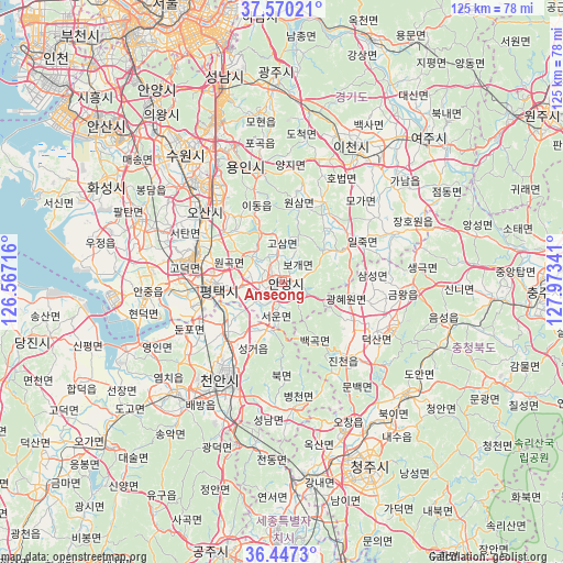
Anseong GPS coordinates[2]
37° 0' 38.988" North, 127° 16' 13.008" East
| Map corner | latitude | longitude |
|---|---|---|
| Upper-left | 37.57021°, | 126.56716° |
| Center: | 37.01083°, | 127.27028° |
| Lower-right: | 36.4473°, | 127.97341° |
| Map W x H: | 124.9×124.9 km | = 77.6×77.6mi |
| max Lat: | 38.37881° ⇑26.6% North |
| Anseong: | 37.01083° |
| min Lat: | ⇓73.4% South 33.25333° |
| min Long | Anseong | max Long |
| 126.10863° | 127.27028° | 129.55377° |
| W 50.3%⇐ | ⇒49.7% E |
Elevation
Elevation of Anseong is 37 m = 121 ft, and this is 33.4 m = 110 ft below average elevation for this country.
| Max E: |
691 m = 2267 ft | 52.8% |
| Avg. | 70.4 m = 231 ft | |
| Anseong | 37 m = 121 ft | |
Min E: |
1 m = 3 ft | 47.2% |
See also: Anseong elevation on elevation.city.
Geographical zone
Anseong is located in North temperate zone (between Tropic of Cancer and the Arctic Circle). Distance of this Northern Tropic circle is 1509.3 km =937.8 mi to South.| Distance of | km | miles | from Anseong |
|---|---|---|---|
| North Pole | 5891.8 | 3661 | to North |
| Arctic Circle | 3286 | 2041.8 | to North |
| Tropic Cancer | 1509.3 | 937.8 | to South |
| Equator | 4115.2 | 2557.1 | to South |


Nearby cities:
15 places around Anseong: (largest is in red/bold)
• Asan
34.6 km =21.5 mi,  223°
223°
• Cheonan
25 km =15.5 mi,  204°
204°
• Cheongju-si
45.9 km =28.5 mi,  154°
154°
• Chinch'ŏn
23 km =14.3 mi,  138°
138°
• Gwangju
44.4 km =27.6 mi,  358°
358°
• Hwaseong-si
45.7 km =28.4 mi,  298°
298°
• Icheon-si
33.5 km =20.8 mi,  27°
27°
• Koesan
51.7 km =32.1 mi,  115°
115°
• Osan
23.7 km =14.7 mi,  311°
311°
• Pubal
37.7 km =23.4 mi, 33°
• Sejong
46.6 km =29 mi,  177°
177°
• Seonghwan
16.3 km =10.1 mi,  229°
229°
• Seongnam-si
49 km =30.4 mi,  346°
346°
• Suwon
38.8 km =24.1 mi,  323°
323°
• Yeoju
45.2 km =28.1 mi,  45°
45°
Sources, notices
• [Note1] Compared only with cities in South Korea existing in our database
• [Src1] Map data: © OpenStreetMap contributors (CC-BY-SA)
• [Src2] Other city data from geonames.org with taken over terms of usage.
• [Src3] Geographical zone / Annual Mean Temperature by Robert A. Rohde @ Wikipedia
