Wŏnju geodata
Wŏnju (Gangwon-do) is a populated place; located in South Korea in Asia/Seoul (GMT+9) time zone. With population of 243,387 people, there are 30 cities with bigger population in this country. Compared to other cities in South Korea, 76.9% of cities are located further ↓South; 76.9% of cities are located further ←West and 85% of cities have lower elevation than Wŏnju. Note1


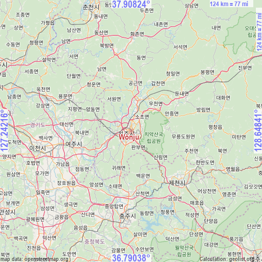
Wŏnju GPS coordinates[2]
37° 21' 5.004" North, 127° 56' 43.008" East
| Map corner | latitude | longitude |
|---|---|---|
| Upper-left | 37.90824°, | 127.24216° |
| Center: | 37.35139°, | 127.94528° |
| Lower-right: | 36.79038°, | 128.64841° |
| Map W x H: | 124.3×124.3 km | = 77.2×77.2mi |
| max Lat: | 38.37881° ⇑23.1% North |
| Wŏnju: | 37.35139° |
| min Lat: | ⇓76.9% South 33.25333° |
| min Long | Wŏnju | max Long |
| 126.10863° | 127.94528° | 129.55377° |
| W 76.9%⇐ | ⇒23.1% E |
Elevation
Elevation of Wŏnju is 133 m = 436 ft, and this is 62.6 m = 205 ft above average elevation for this country.
| Max E: |
691 m = 2267 ft | 15% |
| Wŏnju | 133 m 436 ft | |
| Avg. | 70.4 m = 231 ft | |
Min E: |
1 m = 3 ft | 85% |
See also: Wŏnju elevation on elevation.city.
Geographical zone
Wŏnju is located in North temperate zone (between Tropic of Cancer and the Arctic Circle). Distance of this Northern Tropic circle is 1547.2 km =961.4 mi to South.| Distance of | km | miles | from Wŏnju |
|---|---|---|---|
| North Pole | 5854 | 3637.5 | to North |
| Arctic Circle | 3248.1 | 2018.3 | to North |
| Tropic Cancer | 1547.2 | 961.4 | to South |
| Equator | 4153.1 | 2580.6 | to South |


Nearby cities:
15 places around Wŏnju: (largest is in red/bold)
• Cheongpyeong
63.2 km =39.3 mi,  312°
312°
• Chuncheon
61.1 km =38 mi,  342°
342°
• Dongnae
57.5 km =35.7 mi, 343°
• Gwangju
61.1 km =38 mi,  276°
276°
• Hongch’ŏn
38.2 km =23.7 mi,  352°
352°
• Hwado
65.5 km =40.7 mi,  300°
300°
• Icheon-si
45.2 km =28.1 mi,  259°
259°
• Koesan
61.6 km =38.3 mi,  192°
192°
• Neietsu
49.9 km =31 mi,  111°
111°
• Pubal
39.3 km =24.4 mi, 260°
• Pyeongchang
39.6 km =24.6 mi,  86°
86°
• Seoseok
45.4 km =28.2 mi,  28°
28°
• Sindong
55.6 km =34.5 mi, 338°
• Yangp'yŏng
43 km =26.7 mi,  290°
290°
• Yeoju
28.2 km =17.5 mi, 257°
Sources, notices
• [Note1] Compared only with cities in South Korea existing in our database
• [Src1] Map data: © OpenStreetMap contributors (CC-BY-SA)
• [Src2] Other city data from geonames.org with taken over terms of usage.
• [Src3] Geographical zone / Annual Mean Temperature by Robert A. Rohde @ Wikipedia
