Xam Nua geodata
Xam Nua (Houaphan) is a seat of a first-order administrative division; located in Laos in Asia/Vientiane (GMT+7) time zone. With population of 38,992 people, there are 5 cities with bigger population in this country. Compared to other cities in Laos, 82.7% of cities are located further ↓South; 51.9% of cities are located further ←West and 86.5% of cities have lower elevation than Xam Nua. Note1


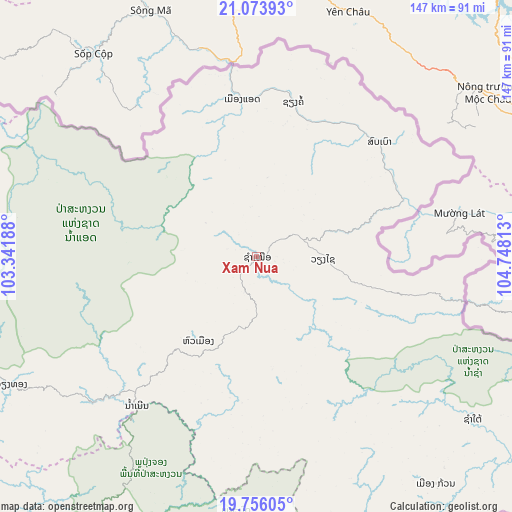
Xam Nua GPS coordinates[2]
20° 24' 59.04" North, 104° 2' 42" East
| Map corner | latitude | longitude |
|---|---|---|
| Upper-left | 21.07393°, | 103.34188° |
| Center: | 20.4164°, | 104.045° |
| Lower-right: | 19.75605°, | 104.74813° |
| Map W x H: | 146.5×146.5 km | = 91×91mi |
| max Lat: | 21.6808° ⇑17.3% North |
| Xam Nua: | 20.4164° |
| min Lat: | ⇓82.7% South 14.11785° |
| min Long | Xam Nua | max Long |
| 100.4178° | 104.045° | 107.26667° |
| W 51.9%⇐ | ⇒48.1% E |
Elevation
Elevation of Xam Nua is 967 m = 3173 ft, and this is 493.4 m = 1619 ft above average elevation for this country.
| Max E: |
1722 m = 5650 ft | 13.5% |
| Xam Nua | 967 m 3173 ft | |
| Avg. | 473.6 m = 1554 ft | |
Min E: |
83 m = 272 ft | 86.5% |
See also: Laos elevation on elevation.city.
Geographical zone
Xam Nua is located in North Torrid zone (between Equator and Tropic of Cancer). Distance of this Northern Tropic circle is 335.8 km =208.7 mi to North.| Distance of | km | miles | from Xam Nua |
|---|---|---|---|
| North Pole | 7737 | 4807.5 | to North |
| Arctic Circle | 5131.1 | 3188.3 | to North |
| Tropic Cancer | 335.8 | 208.7 | to North |
| Equator | 2270.1 | 1410.6 | to South |


Nearby cities:
15 places around Xam Nua: (largest is in red/bold)
• Ban Namnga
160.8 km =99.9 mi,  301°
301°
• Ban Pakla
207.4 km =128.9 mi,  284°
284°
• Ban Xiang-Ngeun
207.8 km =129.1 mi,  249°
249°
• Borikhan
208.8 km =129.7 mi,  189°
189°
• Huameung
35.5 km =22.1 mi,  213°
213°
• Khoa
176.1 km =109.4 mi,  294°
294°
• Luang Prabang
207.9 km =129.2 mi, 253°
• Muang Mok
167.5 km =104.1 mi,  181°
181°
• Muang Phônsavan
139.7 km =86.8 mi,  219°
219°
• Muang Xay
216.8 km =134.7 mi, 278°
• Pakxan
228.4 km =141.9 mi, 190°
• Viangxai
18.7 km =11.6 mi,  93°
93°
• Viengthong
67.1 km =41.7 mi,  261°
261°
• Viengxay
32.3 km =20.1 mi,  104°
104°
• Xamtay
71.9 km =44.7 mi,  136°
136°
Sources, notices
• [Note1] Compared only with cities in Laos existing in our database
• [Src1] Map data: © OpenStreetMap contributors (CC-BY-SA)
• [Src2] Other city data from geonames.org with taken over terms of usage.
• [Src3] Geographical zone / Annual Mean Temperature by Robert A. Rohde @ Wikipedia
