Sidon geodata
Sidon (South Governorate) is a seat of a first-order administrative division; located in Lebanon in Asia/Beirut (GMT+3) time zone. With population of 163,554 people, there are 3 cities with bigger population in this country. Compared to other cities in Lebanon, 68.7% of cities are located further ↑North; 93.7% of cities are located further →East and 96.9% of cities have higher elevation than Sidon. Note1


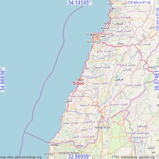
Sidon GPS coordinates[2]
33° 33' 27.036" North, 35° 22' 17.328" East
| Map corner | latitude | longitude |
|---|---|---|
| Upper-left | 34.14145°, | 34.66836° |
| Center: | 33.55751°, | 35.37148° |
| Lower-right: | 32.96959°, | 36.07461° |
| Map W x H: | 130.3×130.3 km | = 81×81mi |
| max Lat: | 34.54278° ⇑68.7% North |
| Sidon: | 33.55751° |
| min Lat: | ⇓31.3% South 33.11023° |
| min Long | Sidon | max Long |
| 35.13972° | 35.37148° | 36.38472° |
| W 6.3%⇐ | ⇒93.7% E |
Elevation
Elevation of Sidon is 9 m = 30 ft, and this is 546.2 m = 1792 ft below average elevation for this country.
| Max E: |
1442 m = 4731 ft | 96.9% |
| Avg. | 555.2 m = 1822 ft | |
| Sidon | 9 m = 30 ft | |
Min E: |
7 m = 23 ft | 3.1% |
See also: Sidon elevation on elevation.city.
Geographical zone
Sidon is located in North temperate zone (between Tropic of Cancer and the Arctic Circle). Distance of this Northern Tropic circle is 1125.3 km =699.2 mi to South.| Distance of | km | miles | from Sidon |
|---|---|---|---|
| North Pole | 6275.8 | 3899.6 | to North |
| Arctic Circle | 3669.9 | 2280.4 | to North |
| Tropic Cancer | 1125.3 | 699.2 | to South |
| Equator | 3731.2 | 2318.5 | to South |


Nearby cities:
15 places around Sidon: (largest is in red/bold)
• Aaley
34.7 km =21.6 mi,  37°
37°
• Baabda
34.6 km =21.5 mi,  27°
27°
• Beirut
39.2 km =24.4 mi,  17°
17°
• Beït ed Dîne
24.6 km =15.3 mi,  51°
51°
• Bhamdoun
37 km =23 mi, 44°
• Bhamdoûn el Mhatta
38.6 km =24 mi, 43°
• Habboûch
19.6 km =12.2 mi,  148°
148°
• Hâsbaïya
34.1 km =21.2 mi,  121°
121°
• Jdaidet el Matn
41.2 km =25.6 mi, 25°
• Jezzîne
19.8 km =12.3 mi,  95°
95°
• Joubb Jannîne
39 km =24.2 mi,  78°
78°
• Marjayoûn
29.9 km =18.6 mi,  137°
137°
• Nabatîyé et Tahta
22.4 km =13.9 mi, 152°
• Ra’s Bayrūt
39.5 km =24.5 mi, 15°
• Tyre
35.6 km =22.1 mi,  207°
207°
Sources, notices
• [Note1] Compared only with cities in Lebanon existing in our database
• [Src1] Map data: © OpenStreetMap contributors (CC-BY-SA)
• [Src2] Other city data from geonames.org with taken over terms of usage.
• [Src3] Geographical zone / Annual Mean Temperature by Robert A. Rohde @ Wikipedia
