Matara geodata
Matara (Southern) is a populated place; located in Sri Lanka in Asia/Colombo (GMT+5.5) time zone. With population of 76,254 people, there are 15 cities with bigger population in this country. Compared to other cities in Sri Lanka, 97.4% of cities are located further ↑North; 67.1% of cities are located further ←West and 78.9% of cities have higher elevation than Matara. Note1


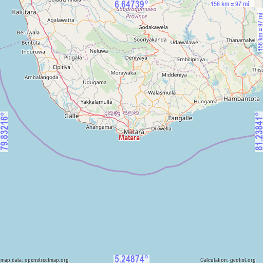
Matara GPS coordinates[2]
5° 56' 54.636" North, 80° 32' 7.008" East
| Map corner | latitude | longitude |
|---|---|---|
| Upper-left | 6.64739°, | 79.83216° |
| Center: | 5.94851°, | 80.53528° |
| Lower-right: | 5.24874°, | 81.23841° |
| Map W x H: | 155.5×155.5 km | = 96.6×96.6mi |
| max Lat: | 9.81667° ⇑97.4% North |
| Matara: | 5.94851° |
| min Lat: | ⇓2.6% South 5.92825° |
| min Long | Matara | max Long |
| 79.79528° | 80.53528° | 81.83472° |
| W 67.1%⇐ | ⇒32.9% E |
Elevation
Elevation of Matara is 9 m = 30 ft, and this is 148.4 m = 487 ft below average elevation for this country.
| Max E: |
1868 m = 6129 ft | 78.9% |
| Avg. | 157.4 m = 516 ft | |
| Matara | 9 m = 30 ft | |
Min E: |
1 m = 3 ft | 21.1% |
See also: Matara elevation on elevation.city.
Geographical zone
Matara is located in North Torrid zone (between Equator and Tropic of Cancer). Distance of Equator is 661.4 km =411 mi to South.| Distance of | km | miles | from Matara |
|---|---|---|---|
| North Pole | 9345.6 | 5807.1 | to North |
| Arctic Circle | 6739.8 | 4187.9 | to North |
| Tropic Cancer | 1944.5 | 1208.3 | to North |
| Equator | 661.4 | 411 | to South |


Nearby cities:
15 places around Matara: (largest is in red/bold)
• Ambalangoda
62.1 km =38.6 mi,  300°
300°
• Bentota
79.8 km =49.6 mi,  311°
311°
• Beruwala
84.9 km =52.8 mi, 313°
• Devinuwara
6.3 km =3.9 mi,  110°
110°
• Galle
37.5 km =23.3 mi,  286°
286°
• Hikkaduwa
52.5 km =32.6 mi, 293°
• Horawala Junction
74.4 km =46.2 mi,  322°
322°
• Kalutara
95 km =59 mi, 317°
• Koggala
23.3 km =14.5 mi,  281°
281°
• Mirissa city
8.5 km =5.3 mi,  268°
268°
• Ratnapura
83.3 km =51.8 mi,  349°
349°
• Talpe
28.9 km =18 mi, 281°
• Tangalle
30.2 km =18.8 mi,  73°
73°
• Unawatuna
32.5 km =20.2 mi, 284°
• Weligama
12 km =7.5 mi, 284°
Sources, notices
• [Note1] Compared only with cities in Sri Lanka existing in our database
• [Src1] Map data: © OpenStreetMap contributors (CC-BY-SA)
• [Src2] Other city data from geonames.org with taken over terms of usage.
• [Src3] Geographical zone / Annual Mean Temperature by Robert A. Rohde @ Wikipedia
