Mazeikiai geodata
Mazeikiai (Telsiai) is a populated place; located in Lithuania in Europe/Vilnius (GMT+3) time zone. With population of 41,309 people, there are 9 cities with bigger population in this country. Compared to other cities in Lithuania, 98.5% of cities are located further ↓South; 83.6% of cities are located further →East and 64.9% of cities have higher elevation than Mazeikiai. Note1


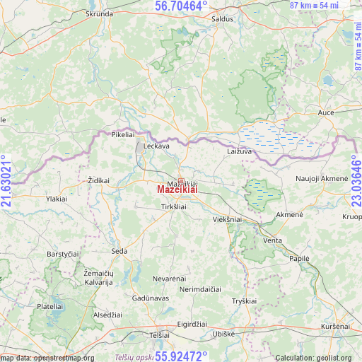
Mazeikiai GPS coordinates[2]
56° 19' 0.012" North, 22° 19' 59.988" East
| Map corner | latitude | longitude |
|---|---|---|
| Upper-left | 56.70464°, | 21.63021° |
| Center: | 56.31667°, | 22.33333° |
| Lower-right: | 55.92472°, | 23.03646° |
| Map W x H: | 86.7×86.7 km | = 53.9×53.9mi |
| max Lat: | 56.36149° ⇑1.5% North |
| Mazeikiai: | 56.31667° |
| min Lat: | ⇓98.5% South 54.01573° |
| min Long | Mazeikiai | max Long |
| 20.99651° | 22.33333° | 26.43984° |
| W 16.4%⇐ | ⇒83.6% E |
Elevation
Elevation of Mazeikiai is 70 m = 230 ft, and this is 20.7 m = 68 ft below average elevation for this country.
| Max E: |
204 m = 669 ft | 64.9% |
| Avg. | 90.7 m = 298 ft | |
| Mazeikiai | 70 m = 230 ft | |
Min E: |
-1 m = -3 ft | 35.1% |
See also: Mazeikiai elevation on elevation.city.
Geographical zone
Mazeikiai is located in North temperate zone (between Tropic of Cancer and the Arctic Circle). Distance of this North polar circle is 1139.3 km =707.9 mi to North.| Distance of | km | miles | from Mazeikiai |
|---|---|---|---|
| North Pole | 3745.2 | 2327.2 | to North |
| Arctic Circle | 1139.3 | 707.9 | to North |
| Tropic Cancer | 3655.9 | 2271.7 | to South |
| Equator | 6261.8 | 3890.9 | to South |


Nearby cities:
15 places around Mazeikiai: (largest is in red/bold)
• Akmenė
26.8 km =16.7 mi,  106°
106°
• Kuršėnai
51.1 km =31.8 mi,  133°
133°
• Naujoji Akmene
34.9 km =21.7 mi,  90°
90°
• Plateliai
43.9 km =27.3 mi,  226°
226°
• Plunge
54.3 km =33.7 mi,  213°
213°
• Rietavas
70.3 km =43.7 mi,  201°
201°
• Salantai
55.4 km =34.4 mi,  238°
238°
• Seda
22.3 km =13.9 mi,  222°
222°
• Skuodas
49.7 km =30.9 mi,  264°
264°
• Telsiai
37.7 km =23.4 mi,  188°
188°
• Užventis
62.6 km =38.9 mi,  161°
161°
• Varniai
63.7 km =39.6 mi,  177°
177°
• Venta
26.3 km =16.3 mi,  121°
121°
• Viekšniai
14.4 km =8.9 mi, 128°
• Žagarė
56.8 km =35.3 mi,  84°
84°
Sources, notices
• [Note1] Compared only with cities in Lithuania existing in our database
• [Src1] Map data: © OpenStreetMap contributors (CC-BY-SA)
• [Src2] Other city data from geonames.org with taken over terms of usage.
• [Src3] Geographical zone / Annual Mean Temperature by Robert A. Rohde @ Wikipedia
