Naujoji Akmene geodata
Naujoji Akmene (Siauliai) is a populated place; located in Lithuania in Europe/Vilnius (GMT+3) time zone. With population of 11,922 people, there are 43 cities with bigger population in this country. Compared to other cities in Lithuania, 98.5% of cities are located further ↓South; 74.6% of cities are located further →East and 52.2% of cities have higher elevation than Naujoji Akmene. Note1


Naujoji Akmene GPS coordinates[2]
56° 19' 0.012" North, 22° 54' 0" East
| Map corner | latitude | longitude |
|---|---|---|
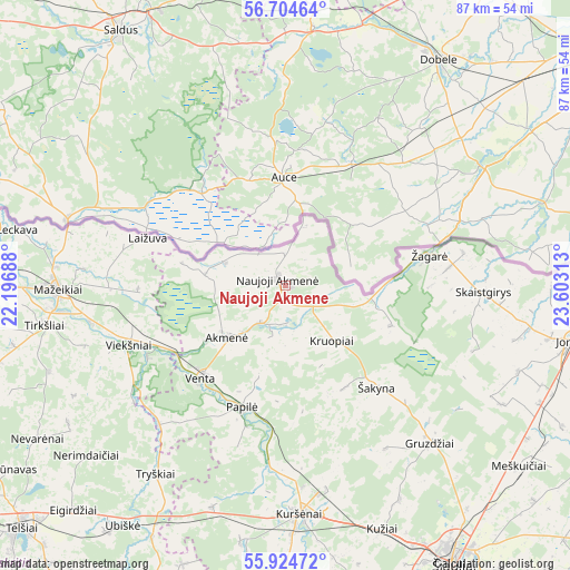
| Upper-left | 56.70464°, | 22.19688° |
| Center: | 56.31667°, | 22.9° |
| Lower-right: | 55.92472°, | 23.60313° |
| Map W x H: | 86.7×86.7 km | = 53.9×53.9mi |
| max Lat: | 56.36149° ⇑1.5% North |
| Naujoji Akmene: | 56.31667° |
| min Lat: | ⇓98.5% South 54.01573° |
| min Long | Naujoji Akmene | max Long |
| 20.99651° | 22.9° | 26.43984° |
| W 25.4%⇐ | ⇒74.6% E |
Elevation
Elevation of Naujoji Akmene is 79 m = 259 ft, and this is 11.7 m = 38 ft below average elevation for this country.
| Max E: |
204 m = 669 ft | 52.2% |
| Avg. | 90.7 m = 298 ft | |
| Naujoji Akmene | 79 m = 259 ft | |
Min E: |
-1 m = -3 ft | 47.8% |
See also: Lithuania elevation on elevation.city.
Geographical zone
Naujoji Akmene is located in North temperate zone (between Tropic of Cancer and the Arctic Circle). Distance of this North polar circle is 1139.3 km =707.9 mi to North.| Distance of | km | miles | from Naujoji Akmene |
|---|---|---|---|
| North Pole | 3745.2 | 2327.2 | to North |
| Arctic Circle | 1139.3 | 707.9 | to North |
| Tropic Cancer | 3655.9 | 2271.7 | to South |
| Equator | 6261.8 | 3890.9 | to South |


Nearby cities:
15 places around Naujoji Akmene: (largest is in red/bold)
• Akmenė
11.9 km =7.4 mi,  231°
231°
• Joniškis
45 km =28 mi,  101°
101°
• Kuršėnai
34.9 km =21.7 mi,  176°
176°
• Linkuva
71 km =44.1 mi,  111°
111°
• Mazeikiai
34.9 km =21.7 mi,  270°
270°
• Pakruojis
70.1 km =43.6 mi,  122°
122°
• Radviliskis
68.1 km =42.3 mi,  144°
144°
• Seda
52.6 km =32.7 mi,  251°
251°
• Telsiai
55 km =34.2 mi, 227°
• Užventis
61.4 km =38.2 mi,  194°
194°
• Varniai
71.6 km =44.5 mi,  207°
207°
• Venta
18.8 km =11.7 mi,  222°
222°
• Viekšniai
25.3 km =15.7 mi, 249°
• Šiauliai
49.8 km =30.9 mi,  148°
148°
• Žagarė
22.2 km =13.8 mi,  77°
77°
Sources, notices
• [Note1] Compared only with cities in Lithuania existing in our database
• [Src1] Map data: © OpenStreetMap contributors (CC-BY-SA)
• [Src2] Other city data from geonames.org with taken over terms of usage.
• [Src3] Geographical zone / Annual Mean Temperature by Robert A. Rohde @ Wikipedia
