Užventis geodata
Užventis (Siauliai) is a populated place; located in Lithuania in Europe/Vilnius (GMT+3) time zone. With population of 827 people, there are 126 cities with bigger population in this country. Compared to other cities in Lithuania, 78.4% of cities are located further ↓South; 79.9% of cities are located further →East and 76.1% of cities have lower elevation than Užventis. Note1


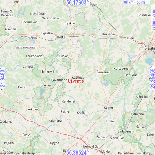
Užventis GPS coordinates[2]
55° 46' 57.504" North, 22° 39' 5.112" East
| Map corner | latitude | longitude |
|---|---|---|
| Upper-left | 56.17603°, | 21.9483° |
| Center: | 55.78264°, | 22.65142° |
| Lower-right: | 55.38524°, | 23.35455° |
| Map W x H: | 87.9×87.9 km | = 54.6×54.6mi |
| max Lat: | 56.36149° ⇑21.6% North |
| Užventis: | 55.78264° |
| min Lat: | ⇓78.4% South 54.01573° |
| min Long | Užventis | max Long |
| 20.99651° | 22.65142° | 26.43984° |
| W 20.1%⇐ | ⇒79.9% E |
Elevation
Elevation of Užventis is 129 m = 423 ft, and this is 38.3 m = 126 ft above average elevation for this country.
| Max E: |
204 m = 669 ft | 23.9% |
| Užventis | 129 m 423 ft | |
| Avg. | 90.7 m = 298 ft | |
Min E: |
-1 m = -3 ft | 76.1% |
See also: Lithuania elevation on elevation.city.
Geographical zone
Užventis is located in North temperate zone (between Tropic of Cancer and the Arctic Circle). Distance of this North polar circle is 1198.7 km =744.8 mi to North.| Distance of | km | miles | from Užventis |
|---|---|---|---|
| North Pole | 3804.6 | 2364.1 | to North |
| Arctic Circle | 1198.7 | 744.8 | to North |
| Tropic Cancer | 3596.5 | 2234.8 | to South |
| Equator | 6202.4 | 3854 | to South |


Nearby cities:
15 places around Užventis: (largest is in red/bold)
• Akmenė
52.3 km =32.5 mi,  6°
6°
• Būgai
41.1 km =25.5 mi,  183°
183°
• Kelmė
24.6 km =15.3 mi,  133°
133°
• Kuršėnai
30.3 km =18.8 mi,  35°
35°
• Plunge
52.4 km =32.6 mi,  285°
285°
• Radviliskis
55.2 km =34.3 mi,  86°
86°
• Raseiniai
53.7 km =33.4 mi,  146°
146°
• Rietavas
46 km =28.6 mi,  262°
262°
• Telsiai
33.5 km =20.8 mi,  311°
311°
• Tytuvėnėliai
37.1 km =23.1 mi,  118°
118°
• Varniai
18 km =11.2 mi, 256°
• Venta
45.6 km =28.3 mi,  3°
3°
• Viekšniai
51.1 km =31.8 mi,  350°
350°
• Šiauliai
44.8 km =27.8 mi,  68°
68°
• Šilalė
43.7 km =27.2 mi,  221°
221°
Sources, notices
• [Note1] Compared only with cities in Lithuania existing in our database
• [Src1] Map data: © OpenStreetMap contributors (CC-BY-SA)
• [Src2] Other city data from geonames.org with taken over terms of usage.
• [Src3] Geographical zone / Annual Mean Temperature by Robert A. Rohde @ Wikipedia
