Šilalė geodata
Šilalė (Tauragė County) is a seat of a second-order administrative division; located in Lithuania in Europe/Vilnius (GMT+3) time zone. With population of 6,026 people, there are 66 cities with bigger population in this country. Compared to other cities in Lithuania, 64.2% of cities are located further ↓South; 85.8% of cities are located further →East and 59% of cities have lower elevation than Šilalė. Note1


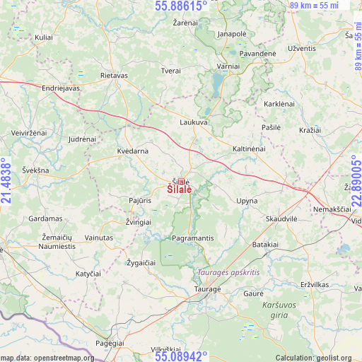
Šilalė GPS coordinates[2]
55° 29' 23.28" North, 22° 11' 12.912" East
| Map corner | latitude | longitude |
|---|---|---|
| Upper-left | 55.88615°, | 21.4838° |
| Center: | 55.4898°, | 22.18692° |
| Lower-right: | 55.08942°, | 22.89005° |
| Map W x H: | 88.6×88.6 km | = 55.1×55.1mi |
| max Lat: | 56.36149° ⇑35.8% North |
| Šilalė: | 55.4898° |
| min Lat: | ⇓64.2% South 54.01573° |
| min Long | Šilalė | max Long |
| 20.99651° | 22.18692° | 26.43984° |
| W 14.2%⇐ | ⇒85.8% E |
Elevation
Elevation of Šilalė is 98 m = 322 ft, and this is 7.3 m = 24 ft above average elevation for this country.
| Max E: |
204 m = 669 ft | 41% |
| Šilalė | 98 m 322 ft | |
| Avg. | 90.7 m = 298 ft | |
Min E: |
-1 m = -3 ft | 59% |
See also: Lithuania elevation on elevation.city.
Geographical zone
Šilalė is located in North temperate zone (between Tropic of Cancer and the Arctic Circle). Distance of this North polar circle is 1231.3 km =765.1 mi to North.| Distance of | km | miles | from Šilalė |
|---|---|---|---|
| North Pole | 3837.2 | 2384.3 | to North |
| Arctic Circle | 1231.3 | 765.1 | to North |
| Tropic Cancer | 3564 | 2214.6 | to South |
| Equator | 6169.9 | 3833.8 | to South |


Nearby cities:
15 places around Šilalė: (largest is in red/bold)
• Būgai
27.9 km =17.3 mi,  107°
107°
• Gargždai
55.5 km =34.5 mi,  296°
296°
• Kelmė
49.6 km =30.8 mi,  71°
71°
• Pagėgiai
42.8 km =26.6 mi,  203°
203°
• Plunge
51.6 km =32.1 mi,  335°
335°
• Priekulė
55.1 km =34.2 mi,  277°
277°
• Rietavas
31.1 km =19.3 mi,  327°
327°
• Rusnė
55.7 km =34.6 mi,  247°
247°
• Silute
47.1 km =29.3 mi, 250°
• Smalininkai
52.5 km =32.6 mi,  151°
151°
• Taurage
27.2 km =16.9 mi,  166°
166°
• Telsiai
54.8 km =34.1 mi,  3°
3°
• Užventis
43.7 km =27.2 mi,  41°
41°
• Varniai
30.6 km =19 mi,  22°
22°
• Žemaičių Naumiestis
33.8 km =21 mi,  244°
244°
Sources, notices
• [Note1] Compared only with cities in Lithuania existing in our database
• [Src1] Map data: © OpenStreetMap contributors (CC-BY-SA)
• [Src2] Other city data from geonames.org with taken over terms of usage.
• [Src3] Geographical zone / Annual Mean Temperature by Robert A. Rohde @ Wikipedia
