Pagėgiai geodata
Pagėgiai (Tauragė County) is a seat of a second-order administrative division; located in Lithuania in Europe/Vilnius (GMT+3) time zone. With population of 2,363 people, there are 88 cities with bigger population in this country. Compared to other cities in Lithuania, 50.7% of cities are located further ↓South; 88.1% of cities are located further →East and 94% of cities have higher elevation than Pagėgiai. Note1


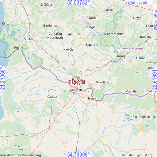
Pagėgiai GPS coordinates[2]
55° 8' 16.548" North, 21° 54' 49.608" East
| Map corner | latitude | longitude |
|---|---|---|
| Upper-left | 55.53782°, | 21.21066° |
| Center: | 55.13793°, | 21.91378° |
| Lower-right: | 54.73399°, | 22.61691° |
| Map W x H: | 89.4×89.4 km | = 55.6×55.6mi |
| max Lat: | 56.36149° ⇑49.3% North |
| Pagėgiai: | 55.13793° |
| min Lat: | ⇓50.7% South 54.01573° |
| min Long | Pagėgiai | max Long |
| 20.99651° | 21.91378° | 26.43984° |
| W 11.9%⇐ | ⇒88.1% E |
Elevation
Elevation of Pagėgiai is 18 m = 59 ft, and this is 72.7 m = 239 ft below average elevation for this country.
| Max E: |
204 m = 669 ft | 94% |
| Avg. | 90.7 m = 298 ft | |
| Pagėgiai | 18 m = 59 ft | |
Min E: |
-1 m = -3 ft | 6% |
See also: Lithuania elevation on elevation.city.
Geographical zone
Pagėgiai is located in North temperate zone (between Tropic of Cancer and the Arctic Circle). Distance of this North polar circle is 1270.4 km =789.4 mi to North.| Distance of | km | miles | from Pagėgiai |
|---|---|---|---|
| North Pole | 3876.3 | 2408.6 | to North |
| Arctic Circle | 1270.4 | 789.4 | to North |
| Tropic Cancer | 3524.8 | 2190.2 | to South |
| Equator | 6130.8 | 3809.5 | to South |


Nearby cities:
15 places around Pagėgiai: (largest is in red/bold)
• Būgai
53.7 km =33.4 mi,  55°
55°
• Gargždai
71.5 km =44.4 mi,  332°
332°
• Gelgaudiškis
68 km =42.3 mi,  95°
95°
• Juodkrantė
67.1 km =41.7 mi,  311°
311°
• Jurbarkas
54.5 km =33.9 mi, 97°
• Neringa
59.8 km =37.2 mi,  295°
295°
• Nida
61.2 km =38 mi,  288°
288°
• Priekulė
59.6 km =37 mi,  320°
320°
• Rietavas
65.5 km =40.7 mi,  0°
0°
• Rusnė
38.8 km =24.1 mi, 297°
• Silute
36 km =22.4 mi, 310°
• Smalininkai
43.2 km =26.8 mi, 99°
• Taurage
27 km =16.8 mi, 61°
• Šilalė
42.8 km =26.6 mi,  23°
23°
• Žemaičių Naumiestis
28 km =17.4 mi, 331°
Sources, notices
• [Note1] Compared only with cities in Lithuania existing in our database
• [Src1] Map data: © OpenStreetMap contributors (CC-BY-SA)
• [Src2] Other city data from geonames.org with taken over terms of usage.
• [Src3] Geographical zone / Annual Mean Temperature by Robert A. Rohde @ Wikipedia
