Joniškis geodata
Joniškis (Siauliai) is a seat of a second-order administrative division; located in Lithuania in Europe/Vilnius (GMT+3) time zone. With population of 11,113 people, there are 47 cities with bigger population in this country. Compared to other cities in Lithuania, 96.3% of cities are located further ↓South; 61.2% of cities are located further →East and 82.8% of cities have higher elevation than Joniškis. Note1


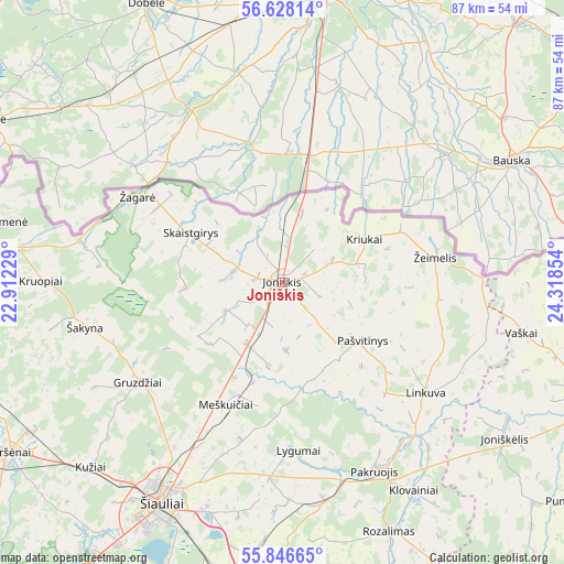
Joniškis GPS coordinates[2]
56° 14' 21.804" North, 23° 36' 55.476" East
| Map corner | latitude | longitude |
|---|---|---|
| Upper-left | 56.62814°, | 22.91229° |
| Center: | 56.23939°, | 23.61541° |
| Lower-right: | 55.84665°, | 24.31854° |
| Map W x H: | 86.9×86.9 km | = 54×54mi |
| max Lat: | 56.36149° ⇑3.7% North |
| Joniškis: | 56.23939° |
| min Lat: | ⇓96.3% South 54.01573° |
| min Long | Joniškis | max Long |
| 20.99651° | 23.61541° | 26.43984° |
| W 38.8%⇐ | ⇒61.2% E |
Elevation
Elevation of Joniškis is 50 m = 164 ft, and this is 40.7 m = 134 ft below average elevation for this country.
| Max E: |
204 m = 669 ft | 82.8% |
| Avg. | 90.7 m = 298 ft | |
| Joniškis | 50 m = 164 ft | |
Min E: |
-1 m = -3 ft | 17.2% |
See also: Lithuania elevation on elevation.city.
Geographical zone
Joniškis is located in North temperate zone (between Tropic of Cancer and the Arctic Circle). Distance of this North polar circle is 1147.9 km =713.3 mi to North.| Distance of | km | miles | from Joniškis |
|---|---|---|---|
| North Pole | 3753.8 | 2332.5 | to North |
| Arctic Circle | 1147.9 | 713.3 | to North |
| Tropic Cancer | 3647.3 | 2266.3 | to South |
| Equator | 6253.2 | 3885.6 | to South |


Nearby cities:
15 places around Joniškis: (largest is in red/bold)
• Akmenė
53.5 km =33.2 mi,  271°
271°
• Birzai
70.3 km =43.7 mi,  93°
93°
• Kuršėnai
49.6 km =30.8 mi,  238°
238°
• Linkuva
27.8 km =17.3 mi,  127°
127°
• Naujamiestis
70 km =43.5 mi,  151°
151°
• Naujoji Akmene
45 km =28 mi,  281°
281°
• Pakruojis
32.6 km =20.3 mi, 152°
• Panevėžys
72.5 km =45 mi,  140°
140°
• Pasvalys
52.8 km =32.8 mi,  112°
112°
• Radviliskis
47.3 km =29.4 mi,  186°
186°
• Venta
57.1 km =35.5 mi,  264°
264°
• Viekšniai
67.9 km =42.2 mi, 269°
• Šeduva
55.2 km =34.3 mi,  170°
170°
• Šiauliai
38.7 km =24 mi,  208°
208°
• Žagarė
26.3 km =16.3 mi,  301°
301°
Sources, notices
• [Note1] Compared only with cities in Lithuania existing in our database
• [Src1] Map data: © OpenStreetMap contributors (CC-BY-SA)
• [Src2] Other city data from geonames.org with taken over terms of usage.
• [Src3] Geographical zone / Annual Mean Temperature by Robert A. Rohde @ Wikipedia
