Radviliskis geodata
Radviliskis (Siauliai) is a populated place; located in Lithuania in Europe/Vilnius (GMT+3) time zone. With population of 20,339 people, there are 29 cities with bigger population in this country. Compared to other cities in Lithuania, 79.1% of cities are located further ↓South; 63.4% of cities are located further →East and 73.1% of cities have lower elevation than Radviliskis. Note1


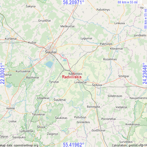
Radviliskis GPS coordinates[2]
55° 49' 0.012" North, 23° 31' 59.988" East
| Map corner | latitude | longitude |
|---|---|---|
| Upper-left | 56.20971°, | 22.83021° |
| Center: | 55.81667°, | 23.53333° |
| Lower-right: | 55.41962°, | 24.23646° |
| Map W x H: | 87.8×87.8 km | = 54.6×54.6mi |
| max Lat: | 56.36149° ⇑20.9% North |
| Radviliskis: | 55.81667° |
| min Lat: | ⇓79.1% South 54.01573° |
| min Long | Radviliskis | max Long |
| 20.99651° | 23.53333° | 26.43984° |
| W 36.6%⇐ | ⇒63.4% E |
Elevation
Elevation of Radviliskis is 124 m = 407 ft, and this is 33.3 m = 109 ft above average elevation for this country.
| Max E: |
204 m = 669 ft | 26.9% |
| Radviliskis | 124 m 407 ft | |
| Avg. | 90.7 m = 298 ft | |
Min E: |
-1 m = -3 ft | 73.1% |
See also: Lithuania elevation on elevation.city.
Geographical zone
Radviliskis is located in North temperate zone (between Tropic of Cancer and the Arctic Circle). Distance of this North polar circle is 1194.9 km =742.5 mi to North.| Distance of | km | miles | from Radviliskis |
|---|---|---|---|
| North Pole | 3800.8 | 2361.7 | to North |
| Arctic Circle | 1194.9 | 742.5 | to North |
| Tropic Cancer | 3600.3 | 2237.1 | to South |
| Equator | 6206.2 | 3856.4 | to South |


Nearby cities:
15 places around Radviliskis: (largest is in red/bold)
• Dotnuva
54.5 km =33.9 mi,  156°
156°
• Joniškis
47.3 km =29.4 mi,  6°
6°
• Kelmė
42.8 km =26.6 mi,  241°
241°
• Kuršėnai
42.6 km =26.5 mi,  299°
299°
• Linkuva
40.5 km =25.2 mi,  42°
42°
• Naujamiestis
41.4 km =25.7 mi,  110°
110°
• Pakruojis
27 km =16.8 mi,  48°
48°
• Panevėžys
51.9 km =32.2 mi,  100°
100°
• Pasvalys
60.5 km =37.6 mi,  63°
63°
• Ramygala
58.7 km =36.5 mi,  124°
124°
• Raseiniai
55 km =34.2 mi,  207°
207°
• Tytuvėnėliai
31.2 km =19.4 mi,  226°
226°
• Užventis
55.2 km =34.3 mi,  266°
266°
• Šeduva
15.8 km =9.8 mi, 118°
• Šiauliai
18.7 km =11.6 mi,  313°
313°
Sources, notices
• [Note1] Compared only with cities in Lithuania existing in our database
• [Src1] Map data: © OpenStreetMap contributors (CC-BY-SA)
• [Src2] Other city data from geonames.org with taken over terms of usage.
• [Src3] Geographical zone / Annual Mean Temperature by Robert A. Rohde @ Wikipedia
