Pakruojis geodata
Pakruojis (Siauliai) is a seat of a second-order administrative division; located in Lithuania in Europe/Vilnius (GMT+3) time zone. With population of 5,964 people, there are 67 cities with bigger population in this country. Compared to other cities in Lithuania, 85.1% of cities are located further ↓South; 54.5% of cities are located further →East and 73.1% of cities have higher elevation than Pakruojis. Note1


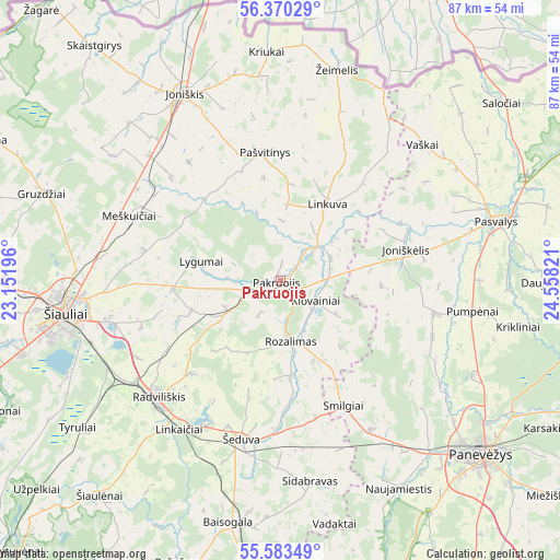
Pakruojis GPS coordinates[2]
55° 58' 44.004" North, 23° 51' 18.288" East
| Map corner | latitude | longitude |
|---|---|---|
| Upper-left | 56.37029°, | 23.15196° |
| Center: | 55.97889°, | 23.85508° |
| Lower-right: | 55.58349°, | 24.55821° |
| Map W x H: | 87.5×87.5 km | = 54.4×54.4mi |
| max Lat: | 56.36149° ⇑14.9% North |
| Pakruojis: | 55.97889° |
| min Lat: | ⇓85.1% South 54.01573° |
| min Long | Pakruojis | max Long |
| 20.99651° | 23.85508° | 26.43984° |
| W 45.5%⇐ | ⇒54.5% E |
Elevation
Elevation of Pakruojis is 61 m = 200 ft, and this is 29.7 m = 97 ft below average elevation for this country.
| Max E: |
204 m = 669 ft | 73.1% |
| Avg. | 90.7 m = 298 ft | |
| Pakruojis | 61 m = 200 ft | |
Min E: |
-1 m = -3 ft | 26.9% |
See also: Lithuania elevation on elevation.city.
Geographical zone
Pakruojis is located in North temperate zone (between Tropic of Cancer and the Arctic Circle). Distance of this North polar circle is 1176.9 km =731.3 mi to North.| Distance of | km | miles | from Pakruojis |
|---|---|---|---|
| North Pole | 3782.8 | 2350.5 | to North |
| Arctic Circle | 1176.9 | 731.3 | to North |
| Tropic Cancer | 3618.4 | 2248.4 | to South |
| Equator | 6224.3 | 3867.6 | to South |


Nearby cities:
15 places around Pakruojis: (largest is in red/bold)
• Birzai
60.7 km =37.7 mi,  66°
66°
• Dotnuva
67.9 km =42.2 mi,  178°
178°
• Joniškis
32.6 km =20.3 mi,  332°
332°
• Kuršėnai
57.2 km =35.5 mi,  272°
272°
• Linkuva
13.9 km =8.6 mi,  31°
31°
• Naujamiestis
37.4 km =23.2 mi,  150°
150°
• Panevėžys
41.2 km =25.6 mi,  131°
131°
• Pasvalys
35.2 km =21.9 mi,  75°
75°
• Radviliskis
27 km =16.8 mi,  228°
228°
• Ramygala
58.7 km =36.5 mi, 151°
• Tytuvėnėliai
58.2 km =36.2 mi, 227°
• Vabalninkas
55.6 km =34.5 mi,  89°
89°
• Šeduva
26.3 km =16.3 mi,  193°
193°
• Šiauliai
33.9 km =21.1 mi,  261°
261°
• Žagarė
56.6 km =35.2 mi,  318°
318°
Sources, notices
• [Note1] Compared only with cities in Lithuania existing in our database
• [Src1] Map data: © OpenStreetMap contributors (CC-BY-SA)
• [Src2] Other city data from geonames.org with taken over terms of usage.
• [Src3] Geographical zone / Annual Mean Temperature by Robert A. Rohde @ Wikipedia
