Linkuva geodata
Linkuva (Siauliai) is a populated place; located in Lithuania in Europe/Vilnius (GMT+3) time zone. With population of 1,719 people, there are 100 cities with bigger population in this country. Compared to other cities in Lithuania, 91.8% of cities are located further ↓South; 53.7% of cities are located further ←West and 53.7% of cities have higher elevation than Linkuva. Note1


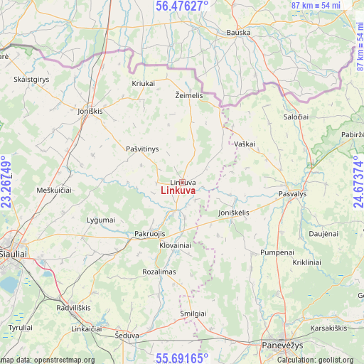
Linkuva GPS coordinates[2]
56° 5' 9.456" North, 23° 58' 14.196" East
| Map corner | latitude | longitude |
|---|---|---|
| Upper-left | 56.47627°, | 23.26749° |
| Center: | 56.08596°, | 23.97061° |
| Lower-right: | 55.69165°, | 24.67374° |
| Map W x H: | 87.2×87.2 km | = 54.2×54.2mi |
| max Lat: | 56.36149° ⇑8.2% North |
| Linkuva: | 56.08596° |
| min Lat: | ⇓91.8% South 54.01573° |
| min Long | Linkuva | max Long |
| 20.99651° | 23.97061° | 26.43984° |
| W 53.7%⇐ | ⇒46.3% E |
Elevation
Elevation of Linkuva is 76 m = 249 ft, and this is 14.7 m = 48 ft below average elevation for this country.
| Max E: |
204 m = 669 ft | 53.7% |
| Avg. | 90.7 m = 298 ft | |
| Linkuva | 76 m = 249 ft | |
Min E: |
-1 m = -3 ft | 46.3% |
See also: Lithuania elevation on elevation.city.
Geographical zone
Linkuva is located in North temperate zone (between Tropic of Cancer and the Arctic Circle). Distance of this North polar circle is 1165 km =723.9 mi to North.| Distance of | km | miles | from Linkuva |
|---|---|---|---|
| North Pole | 3770.9 | 2343.1 | to North |
| Arctic Circle | 1165 | 723.9 | to North |
| Tropic Cancer | 3630.3 | 2255.8 | to South |
| Equator | 6236.2 | 3875 | to South |


Nearby cities:
15 places around Linkuva: (largest is in red/bold)
• Birzai
49.9 km =31 mi,  75°
75°
• Joniškis
27.8 km =17.3 mi,  307°
307°
• Kupiskis
68.5 km =42.6 mi,  113°
113°
• Kuršėnai
64.9 km =40.3 mi,  261°
261°
• Naujamiestis
45.8 km =28.5 mi,  165°
165°
• Naujoji Akmene
71 km =44.1 mi,  291°
291°
• Pakruojis
13.9 km =8.6 mi,  211°
211°
• Panevėžys
45.8 km =28.5 mi,  148°
148°
• Pasvalys
27 km =16.8 mi,  96°
96°
• Radviliskis
40.5 km =25.2 mi,  222°
222°
• Ramygala
66.8 km =41.5 mi,  162°
162°
• Vabalninkas
49.7 km =30.9 mi, 103°
• Šeduva
39.7 km =24.7 mi,  199°
199°
• Šiauliai
44 km =27.3 mi,  247°
247°
• Žagarė
54 km =33.6 mi,  304°
304°
Sources, notices
• [Note1] Compared only with cities in Lithuania existing in our database
• [Src1] Map data: © OpenStreetMap contributors (CC-BY-SA)
• [Src2] Other city data from geonames.org with taken over terms of usage.
• [Src3] Geographical zone / Annual Mean Temperature by Robert A. Rohde @ Wikipedia
