Žagarė geodata
Žagarė (Siauliai) is a populated place; located in Lithuania in Europe/Vilnius (GMT+3) time zone. With population of 2,201 people, there are 91 cities with bigger population in this country. Compared to other cities in Lithuania, 100% of cities are located further ↓South; 67.9% of cities are located further →East and 70.1% of cities have higher elevation than Žagarė. Note1


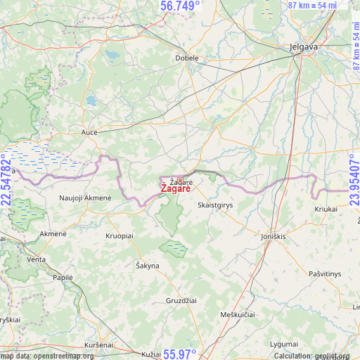
Žagarė GPS coordinates[2]
56° 21' 41.364" North, 23° 15' 3.384" East
| Map corner | latitude | longitude |
|---|---|---|
| Upper-left | 56.749°, | 22.54782° |
| Center: | 56.36149°, | 23.25094° |
| Lower-right: | 55.97°, | 23.95407° |
| Map W x H: | 86.6×86.6 km | = 53.8×53.8mi |
| max Lat: | 56.36149° ⇑0% North |
| Žagarė: | 56.36149° |
| min Lat: | ⇓100% South 54.01573° |
| min Long | Žagarė | max Long |
| 20.99651° | 23.25094° | 26.43984° |
| W 32.1%⇐ | ⇒67.9% E |
Elevation
Elevation of Žagarė is 66 m = 217 ft, and this is 24.7 m = 81 ft below average elevation for this country.
| Max E: |
204 m = 669 ft | 70.1% |
| Avg. | 90.7 m = 298 ft | |
| Žagarė | 66 m = 217 ft | |
Min E: |
-1 m = -3 ft | 29.9% |
See also: Lithuania elevation on elevation.city.
Geographical zone
Žagarė is located in North temperate zone (between Tropic of Cancer and the Arctic Circle). Distance of this North polar circle is 1134.4 km =704.9 mi to North.| Distance of | km | miles | from Žagarė |
|---|---|---|---|
| North Pole | 3740.3 | 2324.1 | to North |
| Arctic Circle | 1134.4 | 704.9 | to North |
| Tropic Cancer | 3660.9 | 2274.8 | to South |
| Equator | 6266.8 | 3894 | to South |


Nearby cities:
15 places around Žagarė: (largest is in red/bold)
• Akmenė
33.3 km =20.7 mi,  248°
248°
• Joniškis
26.3 km =16.3 mi,  121°
121°
• Kuršėnai
44.3 km =27.5 mi,  206°
206°
• Linkuva
54 km =33.6 mi, 124°
• Mazeikiai
56.8 km =35.3 mi,  264°
264°
• Naujoji Akmene
22.2 km =13.8 mi, 257°
• Pakruojis
56.6 km =35.2 mi,  138°
138°
• Radviliskis
63.1 km =39.2 mi,  163°
163°
• Seda
74.8 km =46.5 mi, 253°
• Telsiai
75.1 km =46.7 mi,  235°
235°
• Užventis
74.3 km =46.2 mi, 210°
• Venta
39.2 km =24.4 mi, 241°
• Viekšniai
47.4 km =29.5 mi, 252°
• Šeduva
74.9 km =46.5 mi, 155°
• Šiauliai
47.8 km =29.7 mi,  175°
175°
Sources, notices
• [Note1] Compared only with cities in Lithuania existing in our database
• [Src1] Map data: © OpenStreetMap contributors (CC-BY-SA)
• [Src2] Other city data from geonames.org with taken over terms of usage.
• [Src3] Geographical zone / Annual Mean Temperature by Robert A. Rohde @ Wikipedia
