Wahl geodata
Wahl (Redange) is a seat of a third-order administrative division; located in Luxembourg in Europe/Luxembourg (GMT+2) time zone. With population of 235 people, there are 168 cities with bigger population in this country. Compared to other cities in Luxembourg, 85.9% of cities are located further ↓South; 90.4% of cities are located further →East and 96% of cities have lower elevation than Wahl. Note1


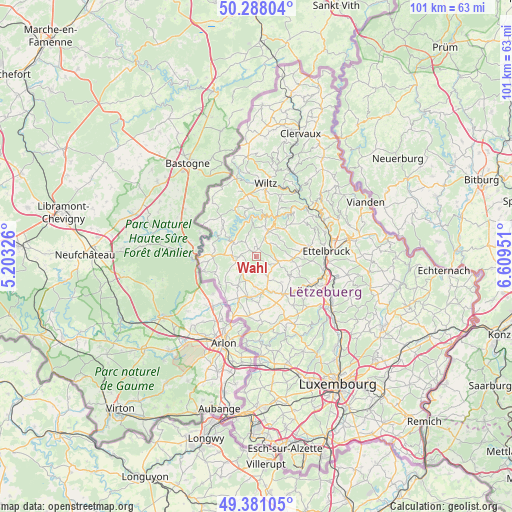
Wahl GPS coordinates[2]
49° 50' 12.012" North, 5° 54' 23.004" East
| Map corner | latitude | longitude |
|---|---|---|
| Upper-left | 50.28804°, | 5.20326° |
| Center: | 49.83667°, | 5.90639° |
| Lower-right: | 49.38105°, | 6.60951° |
| Map W x H: | 100.8×100.8 km | = 62.6×62.6mi |
| max Lat: | 50.13722° ⇑14.1% North |
| Wahl: | 49.83667° |
| min Lat: | ⇓85.9% South 49.45964° |
| min Long | Wahl | max Long |
| 5.76583° | 5.90639° | 6.50532° |
| W 9.6%⇐ | ⇒90.4% E |
Elevation
Elevation of Wahl is 448 m = 1470 ft, and this is 166 m = 545 ft above average elevation for this country.
| Max E: |
502 m = 1647 ft | 4% |
| Wahl | 448 m 1470 ft | |
| Avg. | 282 m = 925 ft | |
Min E: |
143 m = 469 ft | 96% |
See also: Luxembourg elevation on elevation.city.
Geographical zone
Wahl is located in North temperate zone (between Tropic of Cancer and the Arctic Circle). Distance of this North polar circle is 1859.9 km =1155.7 mi to North.| Distance of | km | miles | from Wahl |
|---|---|---|---|
| North Pole | 4465.7 | 2774.9 | to North |
| Arctic Circle | 1859.9 | 1155.7 | to North |
| Tropic Cancer | 2935.4 | 1824 | to South |
| Equator | 5541.3 | 3443.2 | to South |


Nearby cities:
15 places around Wahl: (largest is in red/bold)
• Bavigne
10.3 km =6.4 mi,  336°
336°
• Bettborn
5.2 km =3.2 mi,  151°
151°
• Boulaide
8.6 km =5.3 mi,  311°
311°
• Ell
8.8 km =5.5 mi,  203°
203°
• Esch-sur-Sûre
8.6 km =5.3 mi,  14°
14°
• Goesdorf
10.3 km =6.4 mi,  24°
24°
• Grosbous
4.5 km =2.8 mi,  102°
102°
• Mertzig
7.3 km =4.5 mi,  92°
92°
• Niederfeulen
10.3 km =6.4 mi,  78°
78°
• Perlé
10.5 km =6.5 mi,  254°
254°
• Platen
5.6 km =3.5 mi,  159°
159°
• Rambrouch
4.5 km =2.8 mi,  261°
261°
• Redange-sur-Attert
8.1 km =5 mi,  188°
188°
• Useldange
9.2 km =5.7 mi,  143°
143°
• Vichten
7.7 km =4.8 mi,  119°
119°
Sources, notices
• [Note1] Compared only with cities in Luxembourg existing in our database
• [Src1] Map data: © OpenStreetMap contributors (CC-BY-SA)
• [Src2] Other city data from geonames.org with taken over terms of usage.
• [Src3] Geographical zone / Annual Mean Temperature by Robert A. Rohde @ Wikipedia
