Platen geodata
Platen (Redange) is a populated place; located in Luxembourg in Europe/Luxembourg (GMT+2) time zone. With population of 541 people, there are 145 cities with bigger population in this country. Compared to other cities in Luxembourg, 76.8% of cities are located further ↓South; 84.7% of cities are located further →East and 59.3% of cities have higher elevation than Platen. Note1


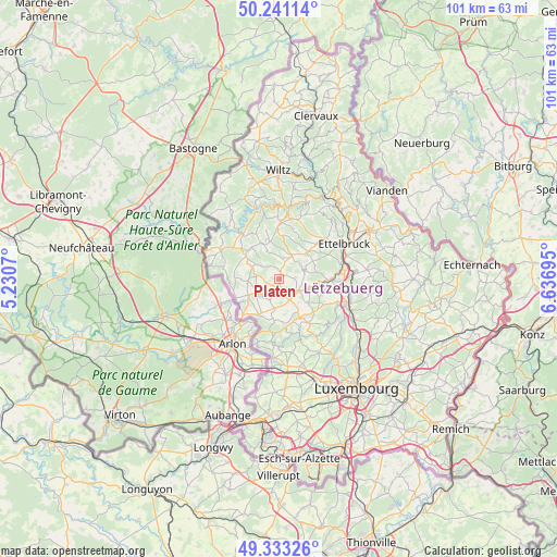
Platen GPS coordinates[2]
49° 47' 21.588" North, 5° 56' 1.752" East
| Map corner | latitude | longitude |
|---|---|---|
| Upper-left | 50.24114°, | 5.2307° |
| Center: | 49.78933°, | 5.93382° |
| Lower-right: | 49.33326°, | 6.63695° |
| Map W x H: | 100.9×100.9 km | = 62.7×62.7mi |
| max Lat: | 50.13722° ⇑23.2% North |
| Platen: | 49.78933° |
| min Lat: | ⇓76.8% South 49.45964° |
| min Long | Platen | max Long |
| 5.76583° | 5.93382° | 6.50532° |
| W 15.3%⇐ | ⇒84.7% E |
Elevation
Elevation of Platen is 267 m = 876 ft, and this is 15 m = 49 ft below average elevation for this country.
| Max E: |
502 m = 1647 ft | 59.3% |
| Avg. | 282 m = 925 ft | |
| Platen | 267 m = 876 ft | |
Min E: |
143 m = 469 ft | 40.7% |
See also: Luxembourg elevation on elevation.city.
Geographical zone
Platen is located in North temperate zone (between Tropic of Cancer and the Arctic Circle). Distance of this North polar circle is 1865.1 km =1158.9 mi to North.| Distance of | km | miles | from Platen |
|---|---|---|---|
| North Pole | 4471 | 2778.1 | to North |
| Arctic Circle | 1865.1 | 1158.9 | to North |
| Tropic Cancer | 2930.1 | 1820.7 | to South |
| Equator | 5536.1 | 3440 | to South |


Nearby cities:
15 places around Platen: (largest is in red/bold)
• Beckerich
7.4 km =4.6 mi,  209°
209°
• Bettborn
0.8 km =0.5 mi,  38°
38°
• Bissen
9.4 km =5.8 mi,  91°
91°
• Boevange-sur-Attert
6.1 km =3.8 mi,  107°
107°
• Brouch
8.7 km =5.4 mi,  132°
132°
• Ell
6.2 km =3.9 mi,  242°
242°
• Grosbous
4.9 km =3 mi,  29°
29°
• Mertzig
7.2 km =4.5 mi,  46°
46°
• Rambrouch
7.9 km =4.9 mi,  305°
305°
• Redange-sur-Attert
4.2 km =2.6 mi,  228°
228°
• Saeul
7.9 km =4.9 mi,  151°
151°
• Tuntange
9.7 km =6 mi, 145°
• Useldange
4.1 km =2.5 mi,  122°
122°
• Vichten
5 km =3.1 mi,  72°
72°
• Wahl
5.6 km =3.5 mi,  339°
339°
Sources, notices
• [Note1] Compared only with cities in Luxembourg existing in our database
• [Src1] Map data: © OpenStreetMap contributors (CC-BY-SA)
• [Src2] Other city data from geonames.org with taken over terms of usage.
• [Src3] Geographical zone / Annual Mean Temperature by Robert A. Rohde @ Wikipedia
