Perlé geodata
Perlé (Redange) is a populated place; located in Luxembourg in Europe/Luxembourg (GMT+2) time zone. With population of 649 people, there are 125 cities with bigger population in this country. Compared to other cities in Luxembourg, 80.8% of cities are located further ↓South; 100% of cities are located further →East and 97.7% of cities have lower elevation than Perlé. Note1


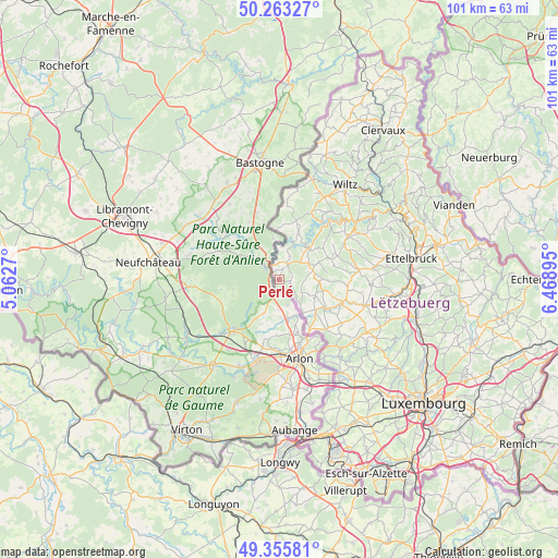
Perlé GPS coordinates[2]
49° 48' 42.012" North, 5° 45' 56.988" East
| Map corner | latitude | longitude |
|---|---|---|
| Upper-left | 50.26327°, | 5.0627° |
| Center: | 49.81167°, | 5.76583° |
| Lower-right: | 49.35581°, | 6.46895° |
| Map W x H: | 100.9×100.9 km | = 62.7×62.7mi |
| max Lat: | 50.13722° ⇑19.2% North |
| Perlé: | 49.81167° |
| min Lat: | ⇓80.8% South 49.45964° |
| min Long | Perlé | max Long |
| 5.76583° | 5.76583° | 6.50532° |
| W 0%⇐ | ⇒100% E |
Elevation
Elevation of Perlé is 484 m = 1588 ft, and this is 202 m = 663 ft above average elevation for this country.
| Max E: |
502 m = 1647 ft | 2.3% |
| Perlé | 484 m 1588 ft | |
| Avg. | 282 m = 925 ft | |
Min E: |
143 m = 469 ft | 97.7% |
See also: Luxembourg elevation on elevation.city.
Geographical zone
Perlé is located in North temperate zone (between Tropic of Cancer and the Arctic Circle). Distance of this North polar circle is 1862.6 km =1157.4 mi to North.| Distance of | km | miles | from Perlé |
|---|---|---|---|
| North Pole | 4468.5 | 2776.6 | to North |
| Arctic Circle | 1862.6 | 1157.4 | to North |
| Tropic Cancer | 2932.6 | 1822.2 | to South |
| Equator | 5538.5 | 3441.5 | to South |


Nearby cities:
15 places around Perlé: (largest is in red/bold)
• Bavigne
13.6 km =8.5 mi,  26°
26°
• Beckerich
12.3 km =7.6 mi,  136°
136°
• Bettborn
12.7 km =7.9 mi,  98°
98°
• Boulaide
9.2 km =5.7 mi,  23°
23°
• Eischen
16.2 km =10.1 mi,  149°
149°
• Ell
8.4 km =5.2 mi,  129°
129°
• Esch-sur-Sûre
16.5 km =10.3 mi,  47°
47°
• Grosbous
14.6 km =9.1 mi,  82°
82°
• Hobscheid
17.4 km =10.8 mi, 141°
• Platen
12.3 km =7.6 mi, 101°
• Rambrouch
6.1 km =3.8 mi,  69°
69°
• Redange-sur-Attert
10.3 km =6.4 mi,  120°
120°
• Useldange
16.2 km =10.1 mi,  106°
106°
• Vichten
16.8 km =10.4 mi,  93°
93°
• Wahl
10.5 km =6.5 mi, 74°
Sources, notices
• [Note1] Compared only with cities in Luxembourg existing in our database
• [Src1] Map data: © OpenStreetMap contributors (CC-BY-SA)
• [Src2] Other city data from geonames.org with taken over terms of usage.
• [Src3] Geographical zone / Annual Mean Temperature by Robert A. Rohde @ Wikipedia
