Bettborn geodata
Bettborn (Redange) is a seat of a third-order administrative division; located in Luxembourg in Europe/Luxembourg (GMT+2) time zone. With population of 231 people, there are 169 cities with bigger population in this country. Compared to other cities in Luxembourg, 77.4% of cities are located further ↓South; 82.5% of cities are located further →East and 52.5% of cities have lower elevation than Bettborn. Note1


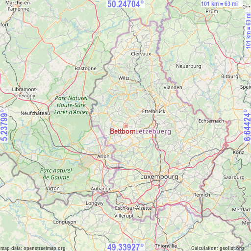
Bettborn GPS coordinates[2]
49° 47' 43.008" North, 5° 56' 27.996" East
| Map corner | latitude | longitude |
|---|---|---|
| Upper-left | 50.24704°, | 5.23799° |
| Center: | 49.79528°, | 5.94111° |
| Lower-right: | 49.33927°, | 6.64424° |
| Map W x H: | 100.9×100.9 km | = 62.7×62.7mi |
| max Lat: | 50.13722° ⇑22.6% North |
| Bettborn: | 49.79528° |
| min Lat: | ⇓77.4% South 49.45964° |
| min Long | Bettborn | max Long |
| 5.76583° | 5.94111° | 6.50532° |
| W 17.5%⇐ | ⇒82.5% E |
Elevation
Elevation of Bettborn is 285 m = 935 ft, and this is 3 m = 10 ft above average elevation for this country.
| Max E: |
502 m = 1647 ft | 47.5% |
| Bettborn | 285 m 935 ft | |
| Avg. | 282 m = 925 ft | |
Min E: |
143 m = 469 ft | 52.5% |
See also: Luxembourg elevation on elevation.city.
Geographical zone
Bettborn is located in North temperate zone (between Tropic of Cancer and the Arctic Circle). Distance of this North polar circle is 1864.5 km =1158.5 mi to North.| Distance of | km | miles | from Bettborn |
|---|---|---|---|
| North Pole | 4470.3 | 2777.7 | to North |
| Arctic Circle | 1864.5 | 1158.5 | to North |
| Tropic Cancer | 2930.8 | 1821.1 | to South |
| Equator | 5536.7 | 3440.3 | to South |


Nearby cities:
15 places around Bettborn: (largest is in red/bold)
• Beckerich
8.3 km =5.2 mi,  210°
210°
• Bissen
9 km =5.6 mi,  95°
95°
• Boevange-sur-Attert
5.9 km =3.7 mi,  115°
115°
• Brouch
8.8 km =5.5 mi,  138°
138°
• Ell
7 km =4.3 mi,  239°
239°
• Grosbous
4.1 km =2.5 mi,  27°
27°
• Mertzig
6.4 km =4 mi,  47°
47°
• Platen
0.8 km =0.5 mi,  218°
218°
• Rambrouch
7.9 km =4.9 mi,  299°
299°
• Redange-sur-Attert
5 km =3.1 mi,  226°
226°
• Saeul
8.2 km =5.1 mi,  156°
156°
• Tuntange
9.9 km =6.2 mi,  150°
150°
• Useldange
4.1 km =2.5 mi,  133°
133°
• Vichten
4.3 km =2.7 mi,  78°
78°
• Wahl
5.2 km =3.2 mi,  331°
331°
Sources, notices
• [Note1] Compared only with cities in Luxembourg existing in our database
• [Src1] Map data: © OpenStreetMap contributors (CC-BY-SA)
• [Src2] Other city data from geonames.org with taken over terms of usage.
• [Src3] Geographical zone / Annual Mean Temperature by Robert A. Rohde @ Wikipedia
