Krāslava geodata
Krāslava (Krāslavas novads) is a seat of a first-order administrative division; located in Latvia in Europe/Riga (GMT+3) time zone. With population of 11,088 people, there are 19 cities with bigger population in this country. Compared to other cities in Latvia, 98.6% of cities are located further ↑North; 93.6% of cities are located further ←West and 81.4% of cities have lower elevation than Krāslava. Note1


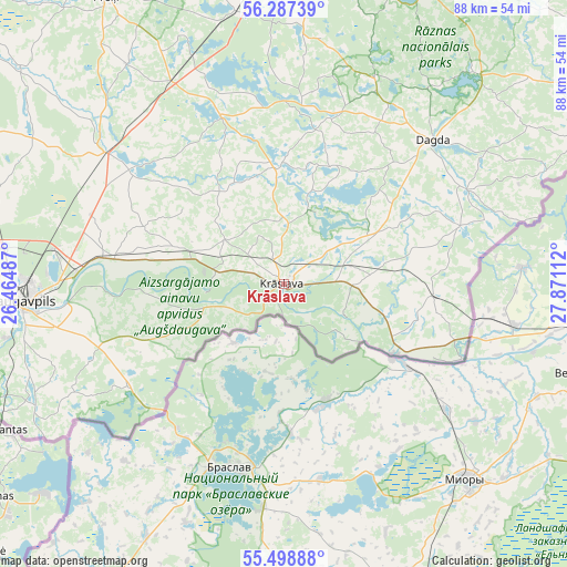
Krāslava GPS coordinates[2]
55° 53' 42.504" North, 27° 10' 4.764" East
| Map corner | latitude | longitude |
|---|---|---|
| Upper-left | 56.28739°, | 26.46487° |
| Center: | 55.89514°, | 27.16799° |
| Lower-right: | 55.49888°, | 27.87112° |
| Map W x H: | 87.7×87.7 km | = 54.5×54.5mi |
| max Lat: | 57.89752° ⇑98.6% North |
| Krāslava: | 55.89514° |
| min Lat: | ⇓1.4% South 55.75284° |
| min Long | Krāslava | max Long |
| 21.01085° | 27.16799° | 28.12165° |
| W 93.6%⇐ | ⇒6.4% E |
Elevation
Elevation of Krāslava is 114 m = 374 ft, and this is 48.6 m = 159 ft above average elevation for this country.
| Max E: |
212 m = 696 ft | 18.6% |
| Krāslava | 114 m 374 ft | |
| Avg. | 65.4 m = 215 ft | |
Min E: |
2 m = 7 ft | 81.4% |
See also: Latvia elevation on elevation.city.
Geographical zone
Krāslava is located in North temperate zone (between Tropic of Cancer and the Arctic Circle). Distance of this North polar circle is 1186.2 km =737.1 mi to North.| Distance of | km | miles | from Krāslava |
|---|---|---|---|
| North Pole | 3792.1 | 2356.3 | to North |
| Arctic Circle | 1186.2 | 737.1 | to North |
| Tropic Cancer | 3609 | 2242.5 | to South |
| Equator | 6215 | 3861.8 | to South |


Nearby cities:
15 places around Krāslava: (largest is in red/bold)
• Aglona
28.3 km =17.6 mi,  339°
339°
• Dagda
32 km =19.9 mi,  45°
45°
• Daugavpils
39.6 km =24.6 mi,  268°
268°
• Ilūkste
55 km =34.2 mi,  279°
279°
• Jaunaglona
31.2 km =19.4 mi, 341°
• Ludza
79.3 km =49.3 mi,  25°
25°
• Līvāni
79.9 km =49.6 mi,  309°
309°
• Preiļi
52.2 km =32.4 mi,  328°
328°
• Riebiņi
54.8 km =34.1 mi, 335°
• Rēzekne
69.2 km =43 mi,  8°
8°
• Silene
28.7 km =17.8 mi,  236°
236°
• Subate
79.4 km =49.3 mi, 278°
• Vecvārkava
53.1 km =33 mi, 309°
• Viļāni
74.6 km =46.4 mi,  348°
348°
• Zilupe
80.4 km =50 mi, 47°
Sources, notices
• [Note1] Compared only with cities in Latvia existing in our database
• [Src1] Map data: © OpenStreetMap contributors (CC-BY-SA)
• [Src2] Other city data from geonames.org with taken over terms of usage.
• [Src3] Geographical zone / Annual Mean Temperature by Robert A. Rohde @ Wikipedia
