Riah geodata
Riah (Casablanca-Settat) is a seat of a third-order administrative division; located in Morocco in Africa/Casablanca (GMT+1) time zone. In our database, there are 108 cities with bigger population. Compared to other cities in Morocco, 50.8% of cities are located further ↓South; 68.6% of cities are located further →East and 58.5% of cities have higher elevation than Riah. Note1


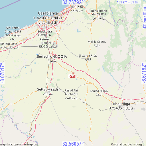
Riah GPS coordinates[2]
33° 9' 4.392" North, 7° 22' 30.144" West
| Map corner | latitude | longitude |
|---|---|---|
| Upper-left | 33.73792°, | -8.07817° |
| Center: | 33.15122°, | -7.37504° |
| Lower-right: | 32.56057°, | -6.67192° |
| Map W x H: | 130.9×130.9 km | = 81.3×81.3mi |
| max Lat: | 35.84906° ⇑49.2% North |
| Riah: | 33.15122° |
| min Lat: | ⇓50.8% South 22.6558° |
| min Long | Riah | max Long |
| -15.60719° | -7.37504° | -1.22855° |
| W 31.4%⇐ | ⇒68.6% E |
Elevation
Elevation of Riah is 357 m = 1171 ft, and this is 259.8 m = 852 ft below average elevation for this country.
| Max E: |
2637 m = 8652 ft | 58.5% |
| Avg. | 616.8 m = 2024 ft | |
| Riah | 357 m = 1171 ft | |
Min E: |
1 m = 3 ft | 41.5% |
See also: Morocco elevation on elevation.city.
Geographical zone
Riah is located in North temperate zone (between Tropic of Cancer and the Arctic Circle). Distance of this Northern Tropic circle is 1080.2 km =671.2 mi to South.| Distance of | km | miles | from Riah |
|---|---|---|---|
| North Pole | 6321 | 3927.7 | to North |
| Arctic Circle | 3715.1 | 2308.5 | to North |
| Tropic Cancer | 1080.2 | 671.2 | to South |
| Equator | 3686.1 | 2290.4 | to South |


Nearby cities:
15 places around Riah: (largest is in red/bold)
• Berrechid
23.5 km =14.6 mi,  302°
302°
• Boujniba
62.5 km =38.8 mi,  116°
116°
• Boulaouane
71.2 km =44.2 mi,  242°
242°
• Bouskoura
42 km =26.1 mi,  322°
322°
• Bouznika
73.7 km =45.8 mi,  15°
15°
• Casablanca
53.3 km =33.1 mi,  335°
335°
• Dar Bouazza
57.6 km =35.8 mi,  314°
314°
• Guisser
44.3 km =27.5 mi,  195°
195°
• Khouribga
53 km =32.9 mi, 124°
• Mediouna
36 km =22.4 mi, 338°
• Mellila
33.5 km =20.8 mi,  40°
40°
• Mohammedia
59.5 km =37 mi,  359°
359°
• Settat
28 km =17.4 mi,  233°
233°
• Tit Mellil
46.4 km =28.8 mi,  347°
347°
• Zawyat an Nwaçer
34.1 km =21.2 mi, 318°
Sources, notices
• [Note1] Compared only with cities in Morocco existing in our database
• [Src1] Map data: © OpenStreetMap contributors (CC-BY-SA)
• [Src2] Other city data from geonames.org with taken over terms of usage.
• [Src3] Geographical zone / Annual Mean Temperature by Robert A. Rohde @ Wikipedia
