Oued Amlil geodata
Oued Amlil (Fès-Meknès) is a seat of a third-order administrative division; located in Morocco in Africa/Casablanca (GMT+1) time zone. In our database, there are 108 cities with bigger population. Compared to other cities in Morocco, 68.2% of cities are located further ↓South; 82.9% of cities are located further ←West and 64.7% of cities have higher elevation than Oued Amlil. Note1


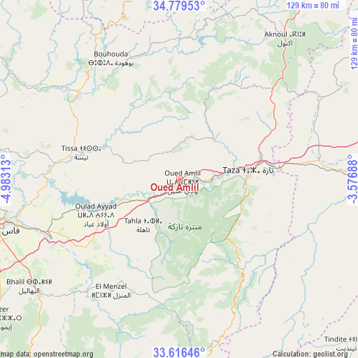
Oued Amlil GPS coordinates[2]
34° 12' 0" North, 4° 16' 48" West
| Map corner | latitude | longitude |
|---|---|---|
| Upper-left | 34.77953°, | -4.98313° |
| Center: | 34.2°, | -4.28° |
| Lower-right: | 33.61646°, | -3.57688° |
| Map W x H: | 129.3×129.3 km | = 80.3×80.3mi |
| max Lat: | 35.84906° ⇑31.8% North |
| Oued Amlil: | 34.2° |
| min Lat: | ⇓68.2% South 22.6558° |
| min Long | Oued Amlil | max Long |
| -15.60719° | -4.28° | -1.22855° |
| W 82.9%⇐ | ⇒17.1% E |
Elevation
Elevation of Oued Amlil is 301 m = 988 ft, and this is 315.8 m = 1036 ft below average elevation for this country.
| Max E: |
2637 m = 8652 ft | 64.7% |
| Avg. | 616.8 m = 2024 ft | |
| Oued Amlil | 301 m = 988 ft | |
Min E: |
1 m = 3 ft | 35.3% |
See also: Morocco elevation on elevation.city.
Geographical zone
Oued Amlil is located in North temperate zone (between Tropic of Cancer and the Arctic Circle). Distance of this Northern Tropic circle is 1196.8 km =743.7 mi to South.| Distance of | km | miles | from Oued Amlil |
|---|---|---|---|
| North Pole | 6204.4 | 3855.2 | to North |
| Arctic Circle | 3598.5 | 2236 | to North |
| Tropic Cancer | 1196.8 | 743.7 | to South |
| Equator | 3802.7 | 2362.9 | to South |


Nearby cities:
15 places around Oued Amlil: (largest is in red/bold)
• Aknoul
63.1 km =39.2 mi,  36°
36°
• Bouarouss
51.8 km =32.2 mi,  290°
290°
• Fès al Bali
63.8 km =39.6 mi,  256°
256°
• Galaz
61.4 km =38.2 mi,  308°
308°
• Matmata
27.4 km =17 mi,  245°
245°
• Oulad Daoud
44.3 km =27.5 mi,  300°
300°
• Sefrou
65 km =40.4 mi,  230°
230°
• Sidi Harazem
58.8 km =36.5 mi, 250°
• Tahla
21.2 km =13.2 mi,  217°
217°
• Taounate
49.9 km =31 mi,  318°
318°
• Taza
24.9 km =15.5 mi,  87°
87°
• Tazarine
36.3 km =22.6 mi,  166°
166°
• Timezgana
59.1 km =36.7 mi, 315°
• Tissa
36.6 km =22.7 mi, 285°
• Tmourghout
40.1 km =24.9 mi,  144°
144°
Sources, notices
• [Note1] Compared only with cities in Morocco existing in our database
• [Src1] Map data: © OpenStreetMap contributors (CC-BY-SA)
• [Src2] Other city data from geonames.org with taken over terms of usage.
• [Src3] Geographical zone / Annual Mean Temperature by Robert A. Rohde @ Wikipedia
