Itzer geodata
Itzer (Béni Mellal-Khénifra) is a seat of a third-order administrative division; located in Morocco in Africa/Casablanca (GMT+1) time zone. In our database, there are 108 cities with bigger population. Compared to other cities in Morocco, 52.7% of cities are located further ↑North; 72.1% of cities are located further ←West and 95.7% of cities have lower elevation than Itzer. Note1


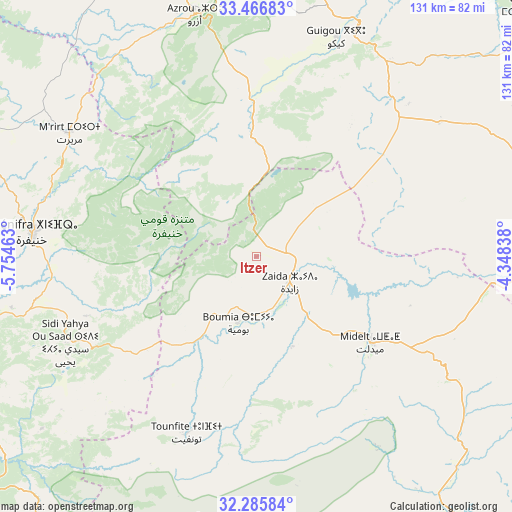
Itzer GPS coordinates[2]
32° 52' 41.88" North, 5° 3' 5.4" West
| Map corner | latitude | longitude |
|---|---|---|
| Upper-left | 33.46683°, | -5.75463° |
| Center: | 32.8783°, | -5.0515° |
| Lower-right: | 32.28584°, | -4.34838° |
| Map W x H: | 131.3×131.3 km | = 81.6×81.6mi |
| max Lat: | 35.84906° ⇑52.7% North |
| Itzer: | 32.8783° |
| min Lat: | ⇓47.3% South 22.6558° |
| min Long | Itzer | max Long |
| -15.60719° | -5.0515° | -1.22855° |
| W 72.1%⇐ | ⇒27.9% E |
Elevation
Elevation of Itzer is 1658 m = 5440 ft, and this is 1041.2 m = 3416 ft above average elevation for this country.
| Max E: |
2637 m = 8652 ft | 4.3% |
| Itzer | 1658 m 5440 ft | |
| Avg. | 616.8 m = 2024 ft | |
Min E: |
1 m = 3 ft | 95.7% |
See also: Morocco elevation on elevation.city.
Geographical zone
Itzer is located in North temperate zone (between Tropic of Cancer and the Arctic Circle). Distance of this Northern Tropic circle is 1049.8 km =652.3 mi to South.| Distance of | km | miles | from Itzer |
|---|---|---|---|
| North Pole | 6351.3 | 3946.5 | to North |
| Arctic Circle | 3745.4 | 2327.3 | to North |
| Tropic Cancer | 1049.8 | 652.3 | to South |
| Equator | 3655.7 | 2271.5 | to South |


Nearby cities:
15 places around Itzer: (largest is in red/bold)
• Aguelmous
80.5 km =50 mi,  293°
293°
• Amersid
56.1 km =34.9 mi,  104°
104°
• Amouguer
68 km =42.3 mi,  170°
170°
• Azrou
63.8 km =39.6 mi,  345°
345°
• Aïn Leuh
53 km =32.9 mi,  329°
329°
• Boulemane
61.8 km =38.4 mi,  29°
29°
• Boumia
17.8 km =11.1 mi,  195°
195°
• Ifrane
72.3 km =44.9 mi,  355°
355°
• Kerrouchen
26.6 km =16.5 mi,  249°
249°
• Khenifra
57.3 km =35.6 mi,  276°
276°
• Midelt
35.8 km =22.2 mi,  126°
126°
• Sidi Amar
73.3 km =45.5 mi, 276°
• Sidi Lamine
93.3 km =58 mi,  272°
272°
• Sidi Yahya Ou Saad
53.9 km =33.5 mi, 245°
• Zawyat ech Cheïkh
85.1 km =52.9 mi, 252°
Sources, notices
• [Note1] Compared only with cities in Morocco existing in our database
• [Src1] Map data: © OpenStreetMap contributors (CC-BY-SA)
• [Src2] Other city data from geonames.org with taken over terms of usage.
• [Src3] Geographical zone / Annual Mean Temperature by Robert A. Rohde @ Wikipedia
