Aïn Leuh geodata
Aïn Leuh (Fès-Meknès) is a populated place; located in Morocco in Africa/Casablanca (GMT+1) time zone. With population of 5,278 people, there are 95 cities with bigger population in this country. Compared to other cities in Morocco, 53.1% of cities are located further ↓South; 62.4% of cities are located further ←West and 91.1% of cities have lower elevation than Aïn Leuh. Note1


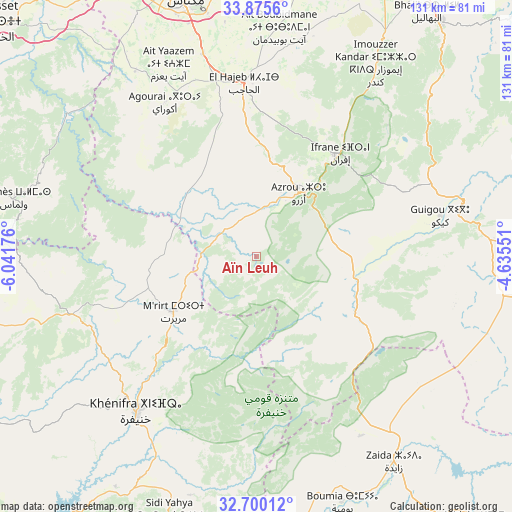
Aïn Leuh GPS coordinates[2]
33° 17' 23.424" North, 5° 20' 19.068" West
| Map corner | latitude | longitude |
|---|---|---|
| Upper-left | 33.8756°, | -6.04176° |
| Center: | 33.28984°, | -5.33863° |
| Lower-right: | 32.70012°, | -4.63551° |
| Map W x H: | 130.7×130.7 km | = 81.2×81.2mi |
| max Lat: | 35.84906° ⇑46.9% North |
| Aïn Leuh: | 33.28984° |
| min Lat: | ⇓53.1% South 22.6558° |
| min Long | Aïn Leuh | max Long |
| -15.60719° | -5.33863° | -1.22855° |
| W 62.4%⇐ | ⇒37.6% E |
Elevation
Elevation of Aïn Leuh is 1424 m = 4672 ft, and this is 807.2 m = 2648 ft above average elevation for this country.
| Max E: |
2637 m = 8652 ft | 8.9% |
| Aïn Leuh | 1424 m 4672 ft | |
| Avg. | 616.8 m = 2024 ft | |
Min E: |
1 m = 3 ft | 91.1% |
See also: Morocco elevation on elevation.city.
Geographical zone
Aïn Leuh is located in North temperate zone (between Tropic of Cancer and the Arctic Circle). Distance of this Northern Tropic circle is 1095.6 km =680.8 mi to South.| Distance of | km | miles | from Aïn Leuh |
|---|---|---|---|
| North Pole | 6305.6 | 3918.1 | to North |
| Arctic Circle | 3699.7 | 2298.9 | to North |
| Tropic Cancer | 1095.6 | 680.8 | to South |
| Equator | 3701.5 | 2300 | to South |


Nearby cities:
15 places around Aïn Leuh: (largest is in red/bold)
• Aguelmous
49.3 km =30.6 mi,  253°
253°
• Azrou
19.4 km =12.1 mi,  34°
34°
• Bhalil
76 km =47.2 mi, 34°
• Boulemane
57.2 km =35.5 mi,  81°
81°
• Boumia
66.7 km =41.4 mi,  160°
160°
• El Hajeb
44.4 km =27.6 mi,  356°
356°
• Ifrane
33.8 km =21 mi,  38°
38°
• Itzer
53 km =32.9 mi,  149°
149°
• Kerrouchen
54.9 km =34.1 mi,  178°
178°
• Khenifra
49.6 km =30.8 mi,  217°
217°
• Meknès
69.8 km =43.4 mi,  343°
343°
• Oulmes
63.4 km =39.4 mi,  283°
283°
• Sefrou
76.6 km =47.6 mi, 38°
• Sidi Amar
59.5 km =37 mi,  230°
230°
• Sidi Yahya Ou Saad
71.4 km =44.4 mi,  198°
198°
Sources, notices
• [Note1] Compared only with cities in Morocco existing in our database
• [Src1] Map data: © OpenStreetMap contributors (CC-BY-SA)
• [Src2] Other city data from geonames.org with taken over terms of usage.
• [Src3] Geographical zone / Annual Mean Temperature by Robert A. Rohde @ Wikipedia
