Aguelmous geodata
Aguelmous (Béni Mellal-Khénifra) is a seat of a third-order administrative division; located in Morocco in Africa/Casablanca (GMT+1) time zone. In our database, there are 108 cities with bigger population. Compared to other cities in Morocco, 51.2% of cities are located further ↓South; 52.7% of cities are located further ←West and 84.5% of cities have lower elevation than Aguelmous. Note1


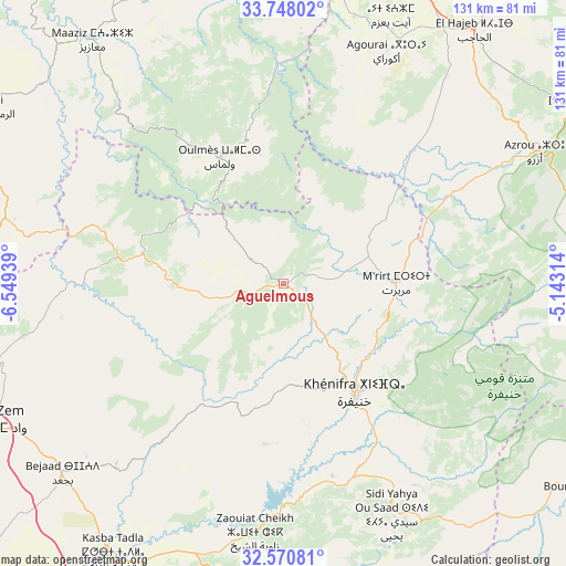
Aguelmous GPS coordinates[2]
33° 9' 41.004" North, 5° 50' 46.536" West
| Map corner | latitude | longitude |
|---|---|---|
| Upper-left | 33.74802°, | -6.54939° |
| Center: | 33.16139°, | -5.84626° |
| Lower-right: | 32.57081°, | -5.14314° |
| Map W x H: | 130.9×130.9 km | = 81.3×81.3mi |
| max Lat: | 35.84906° ⇑48.8% North |
| Aguelmous: | 33.16139° |
| min Lat: | ⇓51.2% South 22.6558° |
| min Long | Aguelmous | max Long |
| -15.60719° | -5.84626° | -1.22855° |
| W 52.7%⇐ | ⇒47.3% E |
Elevation
Elevation of Aguelmous is 1187 m = 3894 ft, and this is 570.2 m = 1871 ft above average elevation for this country.
| Max E: |
2637 m = 8652 ft | 15.5% |
| Aguelmous | 1187 m 3894 ft | |
| Avg. | 616.8 m = 2024 ft | |
Min E: |
1 m = 3 ft | 84.5% |
See also: Morocco elevation on elevation.city.
Geographical zone
Aguelmous is located in North temperate zone (between Tropic of Cancer and the Arctic Circle). Distance of this Northern Tropic circle is 1081.3 km =671.9 mi to South.| Distance of | km | miles | from Aguelmous |
|---|---|---|---|
| North Pole | 6319.9 | 3927 | to North |
| Arctic Circle | 3714 | 2307.8 | to North |
| Tropic Cancer | 1081.3 | 671.9 | to South |
| Equator | 3687.2 | 2291.1 | to South |


Nearby cities:
15 places around Aguelmous: (largest is in red/bold)
• Azrou
65.5 km =40.7 mi,  62°
62°
• Aïn Leuh
49.3 km =30.6 mi,  73°
73°
• El Hajeb
73.3 km =45.5 mi,  36°
36°
• El Ksiba
67.4 km =41.9 mi,  193°
193°
• Ezzhiliga
65.4 km =40.6 mi,  283°
283°
• Kasba Tadla
74 km =46 mi,  212°
212°
• Kerrouchen
63.8 km =39.6 mi,  129°
129°
• Khemisset
76.5 km =47.5 mi,  344°
344°
• Khenifra
30.5 km =19 mi,  145°
145°
• Oued Zem
75.5 km =46.9 mi,  243°
243°
• Oulmes
32.7 km =20.3 mi,  333°
333°
• Sidi Amar
23.6 km =14.7 mi,  176°
176°
• Sidi Lamine
34 km =21.1 mi, 214°
• Sidi Yahya Ou Saad
59.1 km =36.7 mi, 154°
• Zawyat ech Cheïkh
57.9 km =36 mi, 186°
Sources, notices
• [Note1] Compared only with cities in Morocco existing in our database
• [Src1] Map data: © OpenStreetMap contributors (CC-BY-SA)
• [Src2] Other city data from geonames.org with taken over terms of usage.
• [Src3] Geographical zone / Annual Mean Temperature by Robert A. Rohde @ Wikipedia
