Khenifra geodata
Khenifra (Béni Mellal-Khénifra) is a seat of a third-order administrative division; located in Morocco in Africa/Casablanca (GMT+1) time zone. With population of 73,906 people, there are 34 cities with bigger population in this country. Compared to other cities in Morocco, 51.2% of cities are located further ↑North; 56.6% of cities are located further ←West and 67.4% of cities have lower elevation than Khenifra. Note1


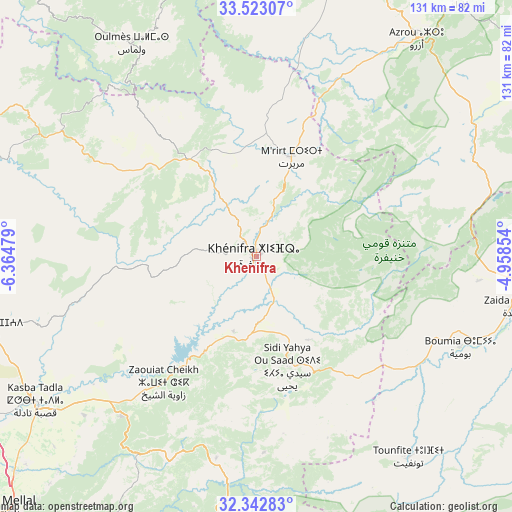
Khenifra GPS coordinates[2]
32° 56' 5.712" North, 5° 39' 42.012" West
| Map corner | latitude | longitude |
|---|---|---|
| Upper-left | 33.52307°, | -6.36479° |
| Center: | 32.93492°, | -5.66167° |
| Lower-right: | 32.34283°, | -4.95854° |
| Map W x H: | 131.2×131.2 km | = 81.5×81.5mi |
| max Lat: | 35.84906° ⇑51.2% North |
| Khenifra: | 32.93492° |
| min Lat: | ⇓48.8% South 22.6558° |
| min Long | Khenifra | max Long |
| -15.60719° | -5.66167° | -1.22855° |
| W 56.6%⇐ | ⇒43.4% E |
Elevation
Elevation of Khenifra is 868 m = 2848 ft, and this is 251.2 m = 824 ft above average elevation for this country.
| Max E: |
2637 m = 8652 ft | 32.6% |
| Khenifra | 868 m 2848 ft | |
| Avg. | 616.8 m = 2024 ft | |
Min E: |
1 m = 3 ft | 67.4% |
See also: Khenifra elevation on elevation.city.
Geographical zone
Khenifra is located in North temperate zone (between Tropic of Cancer and the Arctic Circle). Distance of this Northern Tropic circle is 1056.1 km =656.2 mi to South.| Distance of | km | miles | from Khenifra |
|---|---|---|---|
| North Pole | 6345 | 3942.6 | to North |
| Arctic Circle | 3739.2 | 2323.4 | to North |
| Tropic Cancer | 1056.1 | 656.2 | to South |
| Equator | 3662 | 2275.5 | to South |


Nearby cities:
15 places around Khenifra: (largest is in red/bold)
• Aguelmous
30.5 km =19 mi,  325°
325°
• Azrou
69 km =42.9 mi,  36°
36°
• Aïn Leuh
49.6 km =30.8 mi, 37°
• Boumia
57.3 km =35.6 mi,  114°
114°
• El Ksiba
52.3 km =32.5 mi,  219°
219°
• Ifrane
83.4 km =51.8 mi, 37°
• Itzer
57.3 km =35.6 mi,  96°
96°
• Kasba Tadla
68 km =42.3 mi,  236°
236°
• Kerrouchen
35.5 km =22.1 mi,  115°
115°
• Oued Zem
85.5 km =53.1 mi,  264°
264°
• Oulmes
63.1 km =39.2 mi, 329°
• Sidi Amar
16 km =9.9 mi,  275°
275°
• Sidi Lamine
36.4 km =22.6 mi,  265°
265°
• Sidi Yahya Ou Saad
29.4 km =18.3 mi,  164°
164°
• Zawyat ech Cheïkh
40.2 km =25 mi, 216°
In other languages:
- In Spanish: Jenifra
- In France: Khénifra
- In German: Khénifra
- In Russian: Хенифра
- In Chinese: 海尼夫拉
Sources, notices
• [Note1] Compared only with cities in Morocco existing in our database
• [Src1] Map data: © OpenStreetMap contributors (CC-BY-SA)
• [Src2] Other city data from geonames.org with taken over terms of usage.
• [Src3] Geographical zone / Annual Mean Temperature by Robert A. Rohde @ Wikipedia
