Ifrane geodata
Ifrane (Fès-Meknès) is a seat of a third-order administrative division; located in Morocco in Africa/Casablanca (GMT+1) time zone. With population of 73,782 people, there are 35 cities with bigger population in this country. Compared to other cities in Morocco, 57.4% of cities are located further ↓South; 70.5% of cities are located further ←West and 95.3% of cities have lower elevation than Ifrane. Note1


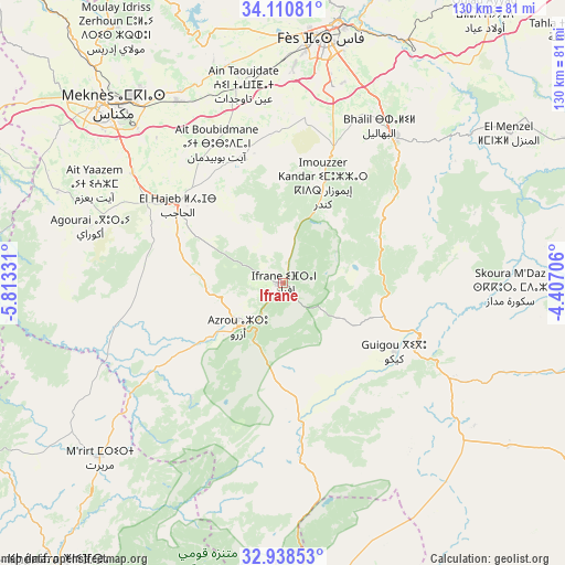
Ifrane GPS coordinates[2]
33° 31' 35.976" North, 5° 6' 36.684" West
| Map corner | latitude | longitude |
|---|---|---|
| Upper-left | 34.11081°, | -5.81331° |
| Center: | 33.52666°, | -5.11019° |
| Lower-right: | 32.93853°, | -4.40706° |
| Map W x H: | 130.3×130.3 km | = 81×81mi |
| max Lat: | 35.84906° ⇑42.6% North |
| Ifrane: | 33.52666° |
| min Lat: | ⇓57.4% South 22.6558° |
| min Long | Ifrane | max Long |
| -15.60719° | -5.11019° | -1.22855° |
| W 70.5%⇐ | ⇒29.5% E |
Elevation
Elevation of Ifrane is 1648 m = 5407 ft, and this is 1031.2 m = 3383 ft above average elevation for this country.
| Max E: |
2637 m = 8652 ft | 4.7% |
| Ifrane | 1648 m 5407 ft | |
| Avg. | 616.8 m = 2024 ft | |
Min E: |
1 m = 3 ft | 95.3% |
See also: Ifrane elevation on elevation.city.
Geographical zone
Ifrane is located in North temperate zone (between Tropic of Cancer and the Arctic Circle). Distance of this Northern Tropic circle is 1121.9 km =697.1 mi to South.| Distance of | km | miles | from Ifrane |
|---|---|---|---|
| North Pole | 6279.2 | 3901.7 | to North |
| Arctic Circle | 3673.4 | 2282.5 | to North |
| Tropic Cancer | 1121.9 | 697.1 | to South |
| Equator | 3727.8 | 2316.3 | to South |


Nearby cities:
15 places around Ifrane: (largest is in red/bold)
• Aguelmous
79.5 km =49.4 mi,  239°
239°
• Azrou
14.5 km =9 mi,  225°
225°
• Aïn Leuh
33.8 km =21 mi,  218°
218°
• Bhalil
42.3 km =26.3 mi,  31°
31°
• Boulemane
39.7 km =24.7 mi,  117°
117°
• El Hajeb
30.1 km =18.7 mi,  306°
306°
• Fès
57.2 km =35.5 mi,  10°
10°
• Fès al Bali
62.1 km =38.6 mi, 13°
• Itzer
72.3 km =44.9 mi,  175°
175°
• Meknès
57.4 km =35.7 mi,  315°
315°
• Moulay Yacoub
62.8 km =39 mi,  353°
353°
• Oulad Tayeb
47.9 km =29.8 mi, 12°
• Sefrou
42.8 km =26.6 mi,  37°
37°
• Sidi Harazem
59.5 km =37 mi,  20°
20°
• Tazouta
46.9 km =29.1 mi,  70°
70°
Sources, notices
• [Note1] Compared only with cities in Morocco existing in our database
• [Src1] Map data: © OpenStreetMap contributors (CC-BY-SA)
• [Src2] Other city data from geonames.org with taken over terms of usage.
• [Src3] Geographical zone / Annual Mean Temperature by Robert A. Rohde @ Wikipedia
