Guisser geodata
Guisser (Casablanca-Settat) is a seat of a third-order administrative division; located in Morocco in Africa/Casablanca (GMT+1) time zone. In our database, there are 108 cities with bigger population. Compared to other cities in Morocco, 54.7% of cities are located further ↑North; 70.9% of cities are located further →East and 51.6% of cities have lower elevation than Guisser. Note1


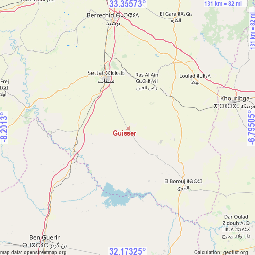
Guisser GPS coordinates[2]
32° 45' 59.22" North, 7° 29' 53.448" West
| Map corner | latitude | longitude |
|---|---|---|
| Upper-left | 33.35573°, | -8.2013° |
| Center: | 32.76645°, | -7.49818° |
| Lower-right: | 32.17325°, | -6.79505° |
| Map W x H: | 131.5×131.5 km | = 81.7×81.7mi |
| max Lat: | 35.84906° ⇑54.7% North |
| Guisser: | 32.76645° |
| min Lat: | ⇓45.3% South 22.6558° |
| min Long | Guisser | max Long |
| -15.60719° | -7.49818° | -1.22855° |
| W 29.1%⇐ | ⇒70.9% E |
Elevation
Elevation of Guisser is 498 m = 1634 ft, and this is 118.8 m = 390 ft below average elevation for this country.
| Max E: |
2637 m = 8652 ft | 48.4% |
| Avg. | 616.8 m = 2024 ft | |
| Guisser | 498 m = 1634 ft | |
Min E: |
1 m = 3 ft | 51.6% |
See also: Morocco elevation on elevation.city.
Geographical zone
Guisser is located in North temperate zone (between Tropic of Cancer and the Arctic Circle). Distance of this Northern Tropic circle is 1037.4 km =644.6 mi to South.| Distance of | km | miles | from Guisser |
|---|---|---|---|
| North Pole | 6363.8 | 3954.3 | to North |
| Arctic Circle | 3757.9 | 2335.1 | to North |
| Tropic Cancer | 1037.4 | 644.6 | to South |
| Equator | 3643.3 | 2263.8 | to South |


Nearby cities:
15 places around Guisser: (largest is in red/bold)
• Al Fqih Ben Çalah
81.4 km =50.6 mi,  111°
111°
• Berrechid
56.1 km =34.9 mi,  351°
351°
• Boujniba
69.2 km =43 mi,  77°
77°
• Boulaouane
53.1 km =33 mi,  281°
281°
• Bouskoura
77.3 km =48 mi, 349°
• Dar Ould Zidouh
75.1 km =46.7 mi,  132°
132°
• Khouribga
56.8 km =35.3 mi, 77°
• Mediouna
76.2 km =47.3 mi,  358°
358°
• Mellila
75.9 km =47.2 mi,  26°
26°
• Oulad Frej
71.4 km =44.4 mi,  287°
287°
• Riah
44.3 km =27.5 mi,  15°
15°
• Settat
28.3 km =17.6 mi,  337°
337°
• Sidi Abdallah
40.5 km =25.2 mi,  230°
230°
• Sidi Moussa
61.6 km =38.3 mi,  153°
153°
• Zawyat an Nwaçer
69.1 km =42.9 mi, 350°
Sources, notices
• [Note1] Compared only with cities in Morocco existing in our database
• [Src1] Map data: © OpenStreetMap contributors (CC-BY-SA)
• [Src2] Other city data from geonames.org with taken over terms of usage.
• [Src3] Geographical zone / Annual Mean Temperature by Robert A. Rohde @ Wikipedia
