Oulmes geodata
Oulmes (Rabat-Salé-Kénitra) is a seat of a third-order administrative division; located in Morocco in Africa/Casablanca (GMT+1) time zone. With population of 19,014 people, there are 80 cities with bigger population in this country. Compared to other cities in Morocco, 55.4% of cities are located further ↓South; 50.4% of cities are located further →East and 84.1% of cities have lower elevation than Oulmes. Note1


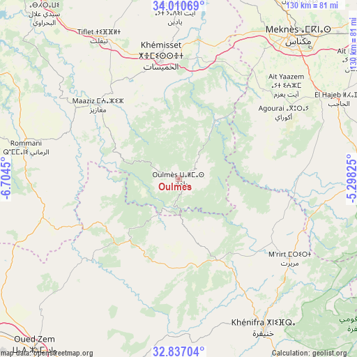
Oulmes GPS coordinates[2]
33° 25' 33.06" North, 6° 0' 4.932" West
| Map corner | latitude | longitude |
|---|---|---|
| Upper-left | 34.01069°, | -6.7045° |
| Center: | 33.42585°, | -6.00137° |
| Lower-right: | 32.83704°, | -5.29825° |
| Map W x H: | 130.5×130.5 km | = 81.1×81.1mi |
| max Lat: | 35.84906° ⇑44.6% North |
| Oulmes: | 33.42585° |
| min Lat: | ⇓55.4% South 22.6558° |
| min Long | Oulmes | max Long |
| -15.60719° | -6.00137° | -1.22855° |
| W 49.6%⇐ | ⇒50.4% E |
Elevation
Elevation of Oulmes is 1175 m = 3855 ft, and this is 558.2 m = 1831 ft above average elevation for this country.
| Max E: |
2637 m = 8652 ft | 15.9% |
| Oulmes | 1175 m 3855 ft | |
| Avg. | 616.8 m = 2024 ft | |
Min E: |
1 m = 3 ft | 84.1% |
See also: Morocco elevation on elevation.city.
Geographical zone
Oulmes is located in North temperate zone (between Tropic of Cancer and the Arctic Circle). Distance of this Northern Tropic circle is 1110.7 km =690.2 mi to South.| Distance of | km | miles | from Oulmes |
|---|---|---|---|
| North Pole | 6290.5 | 3908.7 | to North |
| Arctic Circle | 3684.6 | 2289.5 | to North |
| Tropic Cancer | 1110.7 | 690.2 | to South |
| Equator | 3716.6 | 2309.4 | to South |


Nearby cities:
15 places around Oulmes: (largest is in red/bold)
• Aguelmous
32.7 km =20.3 mi,  153°
153°
• Azrou
72.4 km =45 mi,  89°
89°
• Aïn Leuh
63.4 km =39.4 mi,  103°
103°
• El Hajeb
65.3 km =40.6 mi,  63°
63°
• Ezzhiliga
51 km =31.7 mi,  254°
254°
• Ifrane
83.4 km =51.8 mi,  82°
82°
• Khemisset
44.7 km =27.8 mi,  352°
352°
• Khenifra
63.1 km =39.2 mi, 149°
• Meknès
66.9 km =41.6 mi,  38°
38°
• Oued Zem
82.2 km =51.1 mi,  220°
220°
• Sidi Amar
55.2 km =34.3 mi,  163°
163°
• Sidi Lamine
57.8 km =35.9 mi,  184°
184°
• Sidi Yahya Ou Saad
91.9 km =57.1 mi, 154°
• Tiflet
59.3 km =36.8 mi,  331°
331°
• Zawyat ech Cheïkh
87.2 km =54.2 mi,  174°
174°
Sources, notices
• [Note1] Compared only with cities in Morocco existing in our database
• [Src1] Map data: © OpenStreetMap contributors (CC-BY-SA)
• [Src2] Other city data from geonames.org with taken over terms of usage.
• [Src3] Geographical zone / Annual Mean Temperature by Robert A. Rohde @ Wikipedia
