Akhfennir geodata
Akhfennir (Laâyoune-Sakia El Hamra) is a populated place; located in Morocco in Africa/Casablanca (GMT+1) time zone. With population of 1,583 people, there are 103 cities with bigger population in this country. Compared to other cities in Morocco, 98.4% of cities are located further ↑North; 98.8% of cities are located further →East and 95.3% of cities have higher elevation than Akhfennir. Note1


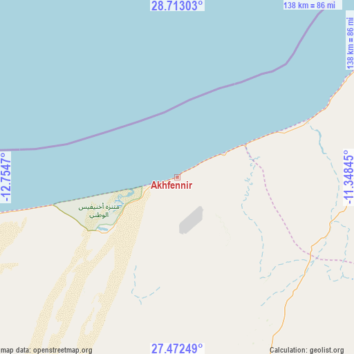
Akhfennir GPS coordinates[2]
28° 5' 40.38" North, 12° 3' 5.652" West
| Map corner | latitude | longitude |
|---|---|---|
| Upper-left | 28.71303°, | -12.7547° |
| Center: | 28.09455°, | -12.05157° |
| Lower-right: | 27.47249°, | -11.34845° |
| Map W x H: | 137.9×137.9 km | = 85.7×85.7mi |
| max Lat: | 35.84906° ⇑98.4% North |
| Akhfennir: | 28.09455° |
| min Lat: | ⇓1.6% South 22.6558° |
| min Long | Akhfennir | max Long |
| -15.60719° | -12.05157° | -1.22855° |
| W 1.2%⇐ | ⇒98.8% E |
Elevation
Elevation of Akhfennir is 15 m = 49 ft, and this is 601.8 m = 1974 ft below average elevation for this country.
| Max E: |
2637 m = 8652 ft | 95.3% |
| Avg. | 616.8 m = 2024 ft | |
| Akhfennir | 15 m = 49 ft | |
Min E: |
1 m = 3 ft | 4.7% |
See also: Morocco elevation on elevation.city.
Geographical zone
Akhfennir is located in North temperate zone (between Tropic of Cancer and the Arctic Circle). Distance of this Northern Tropic circle is 517.9 km =321.8 mi to South.| Distance of | km | miles | from Akhfennir |
|---|---|---|---|
| North Pole | 6883.2 | 4277 | to North |
| Arctic Circle | 4277.4 | 2657.9 | to North |
| Tropic Cancer | 517.9 | 321.8 | to South |
| Equator | 3123.8 | 1941 | to South |


Nearby cities:
15 places around Akhfennir: (largest is in red/bold)
• Agadir
351.4 km =218.3 mi,  42°
42°
• Dakhla
353.5 km =219.7 mi, 43°
• Guelmim
218.6 km =135.8 mi,  63°
63°
• Gueltat Zemmour
329.7 km =204.9 mi,  185°
185°
• Inezgane
350.3 km =217.7 mi, 44°
• Ouijjane
298.1 km =185.2 mi, 55°
• Reggada
282.3 km =175.4 mi,  54°
54°
• Sidi Ifni
232.3 km =144.3 mi, 52°
• Smara
155.4 km =96.6 mi,  166°
166°
• Tafraout
350 km =217.5 mi, 58°
• Tan-Tan
100.4 km =62.4 mi,  67°
67°
• Tanalt
337.1 km =209.5 mi, 56°
• Tarfaya
87.6 km =54.4 mi,  258°
258°
• Tarsouat
337.8 km =209.9 mi, 60°
• Tiznit
287.7 km =178.8 mi, 51°
Sources, notices
• [Note1] Compared only with cities in Morocco existing in our database
• [Src1] Map data: © OpenStreetMap contributors (CC-BY-SA)
• [Src2] Other city data from geonames.org with taken over terms of usage.
• [Src3] Geographical zone / Annual Mean Temperature by Robert A. Rohde @ Wikipedia
