Sidi Ifni geodata
Sidi Ifni (Souss-Massa) is a seat of a third-order administrative division; located in Morocco in Africa/Casablanca (GMT+1) time zone. With population of 20,000 people, there are 78 cities with bigger population in this country. Compared to other cities in Morocco, 97.3% of cities are located further ↑North; 97.7% of cities are located further →East and 85.7% of cities have higher elevation than Sidi Ifni. Note1


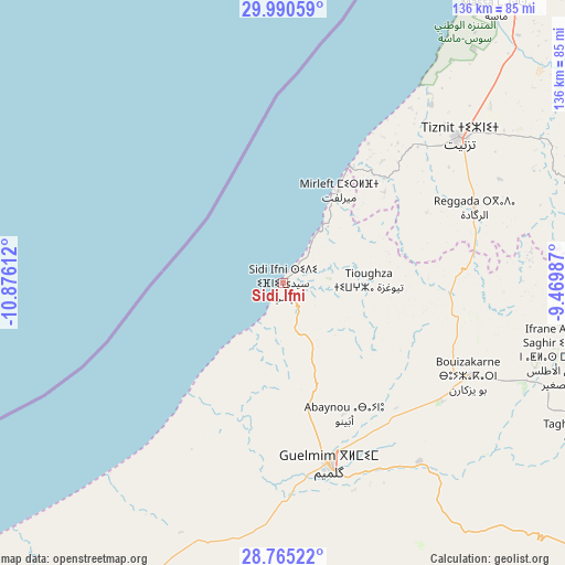
Sidi Ifni GPS coordinates[2]
29° 22' 47.1" North, 10° 10' 22.764" West
| Map corner | latitude | longitude |
|---|---|---|
| Upper-left | 29.99059°, | -10.87612° |
| Center: | 29.37975°, | -10.17299° |
| Lower-right: | 28.76522°, | -9.46987° |
| Map W x H: | 136.2×136.2 km | = 84.6×84.6mi |
| max Lat: | 35.84906° ⇑97.3% North |
| Sidi Ifni: | 29.37975° |
| min Lat: | ⇓2.7% South 22.6558° |
| min Long | Sidi Ifni | max Long |
| -15.60719° | -10.17299° | -1.22855° |
| W 2.3%⇐ | ⇒97.7% E |
Elevation
Elevation of Sidi Ifni is 44 m = 144 ft, and this is 572.8 m = 1879 ft below average elevation for this country.
| Max E: |
2637 m = 8652 ft | 85.7% |
| Avg. | 616.8 m = 2024 ft | |
| Sidi Ifni | 44 m = 144 ft | |
Min E: |
1 m = 3 ft | 14.3% |
See also: Morocco elevation on elevation.city.
Geographical zone
Sidi Ifni is located in North temperate zone (between Tropic of Cancer and the Arctic Circle). Distance of this Northern Tropic circle is 660.8 km =410.6 mi to South.| Distance of | km | miles | from Sidi Ifni |
|---|---|---|---|
| North Pole | 6740.3 | 4188.2 | to North |
| Arctic Circle | 4134.5 | 2569.1 | to North |
| Tropic Cancer | 660.8 | 410.6 | to South |
| Equator | 3266.7 | 2029.8 | to South |


Nearby cities:
15 places around Sidi Ifni: (largest is in red/bold)
• Agadir
128.3 km =79.7 mi,  25°
25°
• Aourir
134.1 km =83.3 mi,  22°
22°
• Dakhla
129.2 km =80.3 mi, 27°
• Guelmim
45.1 km =28 mi,  165°
165°
• Inezgane
124.6 km =77.4 mi, 29°
• Ouijjane
67.2 km =41.8 mi,  65°
65°
• Oulad Teïma
146.2 km =90.8 mi,  39°
39°
• Reggada
50.8 km =31.6 mi,  64°
64°
• Tabia
144.8 km =90 mi, 59°
• Tafraout
122.1 km =75.9 mi, 71°
• Taghazout
136.7 km =84.9 mi, 18°
• Tan-Tan
138.4 km =86 mi,  220°
220°
• Tanalt
106.7 km =66.3 mi, 65°
• Tarsouat
113.2 km =70.3 mi,  78°
78°
• Tiznit
55.4 km =34.4 mi,  50°
50°
Sources, notices
• [Note1] Compared only with cities in Morocco existing in our database
• [Src1] Map data: © OpenStreetMap contributors (CC-BY-SA)
• [Src2] Other city data from geonames.org with taken over terms of usage.
• [Src3] Geographical zone / Annual Mean Temperature by Robert A. Rohde @ Wikipedia
